How long did it take to you to ignore Xangsane?

Interval of time before ignoring

  • First interaction

    Votes: 6 26.1%
  • A few days

    Votes: 2 8.7%
  • A week

    Votes: 1 4.3%
  • 1-3 months

    Votes: 4 17.4%
  • 3-6 months

    Votes: 10 43.5%

  • Total voters
    23
SidharthTheSlayer

SidharthTheSlayer

Anti-Cosmic Satanist
Joined
Jun 2, 2023
Posts
4,654
Reputation
9,207
I found his autism entertaining until he started spamming the same threads about BBC cucking him and hurricane fanfiction over and over again. Then he became racist to me despite whining about how he was made fun of for being mixed race. Then someone leaked his face reveal to me and it looked so Faceapped it became a borderline painting and that was the last straw
 
Last edited:
  • JFL
  • +1
  • WTF
Reactions: Mike141, RAMU KAKA, Mosh12 and 9 others
I don’t
 
  • +1
  • Love it
Reactions: ReadBooksEveryday, Xangsane and datboijj
I don’t have him on ignore. Or anyone else. If I did ignore people, it would just be the self-hating pajeets.
 
  • +1
  • Love it
  • JFL
Reactions: RAMU KAKA, Tabula Rasa, Big White Cuck and 10 others
I have 0 people ignored 🤪
 
  • +1
  • Love it
  • JFL
Reactions: RAMU KAKA, Tabula Rasa, Skywalker and 7 others
Anyway, I found his autism entertaining until he started spamming the same threads about BBC cucking him and hurricane fanfiction over and over again. Then he became racist to me despite whining about how he was made fun of for being mixed race. Then someone leaked his face reveal to me and it looked so Faceapped it became a borderline painting and that was the last straw
 
  • JFL
Reactions: ReadBooksEveryday
Anyway, I found his autism entertaining until he started spamming the same threads about BBC cucking him and hurricane fanfiction over and over again. Then he became racist to me despite whining about how he was made fun of for being mixed race. Then someone leaked his face reveal to me and it looked so Faceapped it became a borderline painting and that was the last straw
What's the BBC cucking him thing
 
What's the BBC cucking him thing
And so on
 
  • JFL
Reactions: Kamui
His “face reveal” is literally just an ai generated pic lmaoo
 
  • +1
  • JFL
  • WTF
Reactions: Mike141, arabcelxxx, Mosh12 and 8 others
Never will
 
  • Love it
Reactions: Xangsane
  • JFL
Reactions: Skywalker
actually quite late

i didnt have anything against him until he posted the storm shit. was an unfunny meme but he just kept on posting about it every other day so i had to put him on the black list
 
  • +1
  • WTF
Reactions: Xangsane, SidharthTheSlayer, murdah and 1 other person
actually quite late

i didnt have anything against him until he posted the storm shit. was an unfunny meme but he just kept on posting about it every other day so i had to put him on the black list
is this referring to the humberto storm thing?
 
  • JFL
Reactions: Xangsane
Ignoring is lame
 
  • +1
  • JFL
Reactions: TechnoBoss and datboijj
is this referring to the humberto storm thing?
no idea

smth about juva. never rly followed it after the first threads i put zim on ignore
 
  • WTF
Reactions: Xangsane
Ever since he started with the hurricane shit
 
  • +1
  • JFL
Reactions: wsada, datboijj and SidharthTheSlayer
no idea

smth about juva. never rly followed it after the first threads i put zim on ignore
if you don’t understand the storm shit you are just too new. or I am too old.
 
  • JFL
Reactions: buflek and wsada
I found his autism entertaining until he started spamming the same threads about BBC cucking him and hurricane fanfiction over and over again. Then he became racist to me despite whining about how he was made fun of for being mixed race. Then someone leaked his face reveal to me and it looked so Faceapped it became a borderline painting and that was the last straw
pat me
 
no idea

smth about juva. never rly followed it after the first threads i put zim on ignore

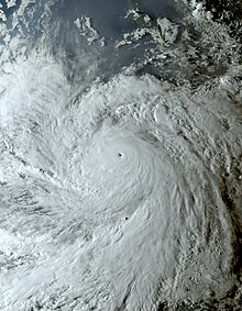
Hurricane Jova (2023)​

Add languages
Tools


From Wikipedia, the free encyclopedia

For other storms of the same name, see List of storms named Jova.
Hurricane Jova
Overall effects
Category 5 hurricane
Meteorological history

Jova nearing its peak intensity on September 7
FormedSeptember 4, 2023
Remnant lowSeptember 10, 2023
DissipatedSeptember 12, 2023
1-minute sustained (SSHWS/NWS)
Highest winds160 mph (260 km/h)
Lowest pressure929 mbar (hPa); 27.43 inHg
FatalitiesNone reported
DamageMinimal
Areas affectedWestern Mexico, Baja California peninsula, Southwestern United States

Part of the 2023 Pacific hurricane season
Hurricane Jova was a very powerful tropical cyclone that became the first Pacific hurricane to reach Category 5 strength on the Saffir-Simpson scale since Willa in 2018. Jova was also one of the fastest–intensifying tropical cyclones on record in the Eastern Pacific tropical cyclone basin.[1] Jova was the tenth named storm, seventh hurricane, fifth major hurricane[a] and first Category 5 hurricane of the 2023 Pacific hurricane season.
Jova originated from a tropical wave that entered the Pacific Ocean on September 1. The system briskly organized and became a tropical depression the following day. After brief inhibition by wind shear, Jova explosively organized over the next two days. It formed a prominent central dense overcast on September 5 and nascent eye feature, signaling its intensification into a hurricane. In a 24-hour period ending early on September 7, Jova's maximum sustained winds increased by 90 mph (150 km/h) to its peak of 160 mph (260 km/h) and its central pressure fell 64 mbar (hPa; 1.89 inHg) to its minimum of 929 mbar (hPa; 27.43 inHg). This made it a Category 5 hurricane and was one of the five-fastest periods of intensification on record in the basin. Thereafter, an eyewall replacement cycle and decreasing sea surface temperatures caused the storm to steadily weaken. It fell below major hurricane status on September 8 and further weakened to a tropical storm on September 9. The total collapse of convection on September 10 marked its degeneration into a remnant low. The system later dissipated on September 12 as it opened up into a trough.
Jova's expansive cloud shield led to some rainfall in western states of Mexico with minor flooding occurring in Baja California Sur. Large waves and rip currents affected coastal areas from Sinaloa northward to the San Francisco Bay Area in California.

Meteorological history[edit]​

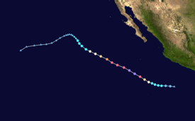
Map plotting the storm's track and intensity, according to the Saffir–Simpson scale
show
Map key
On August 31, 2023, the National Hurricane Center (NHC) began forecasting the possibility of tropical cyclogenesis off the southwest coast of Mexico.[3] The following day, a tropical wave crossed into the Pacific Ocean near El Salvador. Environmental conditions favored development and the NHC assessed a high likelihood of the system becoming a tropical cyclone within seven days.[4] Convective activity began organizing on September 3 as a broad area of low pressure coalesced.[5][6] On September 4, the system developed a well-defined surface circulation accompanied by a prominent banding feature to its west. Based on the improved organization, the NHC assessed the formation of Tropical Depression Eleven-E at 21:00 UTC. The environment ahead of the cyclone proved exceptionally conducive to rapid intensification with ample low-level moisture, low wind shear, and high sea surface temperatures. A deep-layer ridge anchored over northern Mexico steered the depression on a west to west-northwest course and would remain the dominant steering factor throughout the cyclone's duration.[7] While initially hampered by moderate wind shear early on September 5,[8] strengthening began later that day as upper-level outflow improved and deep convection blossomed over the system's center. Concurrent with the improved structure, the NHC estimated the system to have reached tropical storm intensity at 09:00 UTC, and the storm received the name Jova.[9]
Hurricane Jova rapidly intensifying over the course of the day on September 6
Rapid intensification ensued later on September 5 as a central dense overcast developed with tops reaching −112 °F (−80 °C). Imagery from the GPM Microwave Imager depicted the beginnings of a mid-level eyewall.[10][11] This trend continued into September 6 as cloud tops deepened to −130 °F (−90 °C) and Jova's eye became more defined on infrared and visible satellite imagery. Following this, the NHC upgraded Jova to a hurricane at 09:00 UTC.[12] Dramatic intensification continued throughout September 6 into the early hours of September 7. A well-defined 12 mi (19 km) wide pinhole eye formed within a symmetrical convective mass. Extensive lightning was detected within the eyewall by the GOES-16 Geostationary Lightning Mapper. Jova's intensification culminated at 03:00 UTC when it reached Category 5 hurricane status.[13] Jova's maximum sustained winds peaked at 160 mph (260 km/h) and its central pressure fell to 929 mbar (hPa; 27.43 inHg).[14] Within a 24-hour period Jova's winds increased by 90 mph (150 km/h), ranking it among the top six fastest intensification episodes in the Eastern Pacific basin on record.[13][15]
Upon reaching its peak on September 7, Jova began an eyewall replacement cycle (ERC) whereby its small eye was replaced by a larger one.[13] Its convective structure became less symmetric as convective bursts occurred along the south side of its center and overall cloud tops warmed.[16] By the latter half of the day weakening ensued with the hurricane's inner core collapsing as the ERC progressed and its eye becoming obscured by clouds.[17] The hurricane's structure steadily degraded with the inner and outer cores fragmenting as dry air was pulled into the circulation. Jova weakened below major hurricane status by 09:00 UTC on September 8.[18] Later that day, Jova crossed a sharp sea surface temperature gradient, with temperatures ahead of the hurricane dropping substantially. Banding features surrounding the hurricane began breaking apart at this time.[19] Early on September 9, Jova's eye completely disappeared and deep convection became limited to the western half of the storm, soon after, the system was downgraded to a tropical storm. Jova's movement shifted northwest as it reached the edge of the ridge that had been steering it west-northwest.[20][21] Throughout September 9 convection pulsated as Jova's weakening trend briefly reprieved,[22][23] however, the storm's convection continued its collapse on September 10 as Jova traversed 23 °C (73 °F) waters.[24] With the complete loss of convective activity later that day, Jova degenerated into a remnant low by 21:00 UTC marking the cessation of it being a tropical cyclone.[25] The remnants of Jova turned west-southwest and dissipated as it opened up into a trough on September 12.[26]

Preparations and impact[edit]​

Mexico[edit]​

Mexico's Servicio Meteorológico Nacional warned of heavy rains in Baja California Sur, Colima, Jalisco, Nayarit, and Sinaloa stemming from Jova's immense cloud shield. Waves of 6.6–13.1 ft (2–4 m) were expected along the coasts of Colima, Jalisco, Nayarit and Sinaloa.[27] Four beaches in Los Cabos closed due to dangerous conditions. Heavy rains in Baja California Sur swelled small streams, flooded roads, and caused some vehicles to become stranded.[28]

Southwestern United States[edit]​

Increased swells produced by Hurricane Jova on September 10 in Pacific Palisades, California
Moisture associated with Jova was pulled into the Southwestern United States by upper-level southwesterly flow,[29] reaching California on September 10. This led to increased humidity in coastal areas.[30][31] Minimal rainfall was recorded that day in the mountains of southern California. While Doppler weather radar returns showed rain in the region, dryer low- to mid-level air evaporated the rainfall before it reached the ground.[32][33] Waves of 5–8 ft (1.5–2.4 m) and rip currents were forecast for south-facing beaches in Los Angeles and Ventura Counties as well as the Channel Islands. This prompted a high surf advisory for the region.[34][35] The San Francisco Bay Area farther north faced similar risks with rip currents and breaking waves up to 8 ft (2.4 m).[36] Five people were rescued in Ocean Beach, San Francisco, after being pulled to sea by rip currents on September 10.[37]

See also[edit]​

 
  • WTF
  • JFL
Reactions: datboijj and diamondbill

Hurricane Jova (2023)​

Add languages
Tools


From Wikipedia, the free encyclopedia

For other storms of the same name, see List of storms named Jova.
Hurricane Jova
Meteorological history
Category 5 hurricane
Overall effects

Jova nearing its peak intensity on September 7
FormedSeptember 4, 2023
Remnant lowSeptember 10, 2023
DissipatedSeptember 12, 2023
1-minute sustained (SSHWS/NWS)
Highest winds160 mph (260 km/h)
Lowest pressure929 mbar (hPa); 27.43 inHg
FatalitiesNone reported
DamageMinimal
Areas affectedWestern Mexico, Baja California peninsula, Southwestern United States

Part of the 2023 Pacific hurricane season
Hurricane Jova was a very powerful tropical cyclone that became the first Pacific hurricane to reach Category 5 strength on the Saffir-Simpson scale since Willa in 2018. Jova was also one of the fastest–intensifying tropical cyclones on record in the Eastern Pacific tropical cyclone basin.[1] Jova was the tenth named storm, seventh hurricane, fifth major hurricane[a] and first Category 5 hurricane of the 2023 Pacific hurricane season.
Jova originated from a tropical wave that entered the Pacific Ocean on September 1. The system briskly organized and became a tropical depression the following day. After brief inhibition by wind shear, Jova explosively organized over the next two days. It formed a prominent central dense overcast on September 5 and nascent eye feature, signaling its intensification into a hurricane. In a 24-hour period ending early on September 7, Jova's maximum sustained winds increased by 90 mph (150 km/h) to its peak of 160 mph (260 km/h) and its central pressure fell 64 mbar (hPa; 1.89 inHg) to its minimum of 929 mbar (hPa; 27.43 inHg). This made it a Category 5 hurricane and was one of the five-fastest periods of intensification on record in the basin. Thereafter, an eyewall replacement cycle and decreasing sea surface temperatures caused the storm to steadily weaken. It fell below major hurricane status on September 8 and further weakened to a tropical storm on September 9. The total collapse of convection on September 10 marked its degeneration into a remnant low. The system later dissipated on September 12 as it opened up into a trough.
Jova's expansive cloud shield led to some rainfall in western states of Mexico with minor flooding occurring in Baja California Sur. Large waves and rip currents affected coastal areas from Sinaloa northward to the San Francisco Bay Area in California.

Meteorological history[edit]​

Map plotting the storm's track and intensity, according to the Saffir–Simpson scale
show
Map key
On August 31, 2023, the National Hurricane Center (NHC) began forecasting the possibility of tropical cyclogenesis off the southwest coast of Mexico.[3] The following day, a tropical wave crossed into the Pacific Ocean near El Salvador. Environmental conditions favored development and the NHC assessed a high likelihood of the system becoming a tropical cyclone within seven days.[4] Convective activity began organizing on September 3 as a broad area of low pressure coalesced.[5][6] On September 4, the system developed a well-defined surface circulation accompanied by a prominent banding feature to its west. Based on the improved organization, the NHC assessed the formation of Tropical Depression Eleven-E at 21:00 UTC. The environment ahead of the cyclone proved exceptionally conducive to rapid intensification with ample low-level moisture, low wind shear, and high sea surface temperatures. A deep-layer ridge anchored over northern Mexico steered the depression on a west to west-northwest course and would remain the dominant steering factor throughout the cyclone's duration.[7] While initially hampered by moderate wind shear early on September 5,[8] strengthening began later that day as upper-level outflow improved and deep convection blossomed over the system's center. Concurrent with the improved structure, the NHC estimated the system to have reached tropical storm intensity at 09:00 UTC, and the storm received the name Jova.[9]
Hurricane Jova rapidly intensifying over the course of the day on September 6
Rapid intensification ensued later on September 5 as a central dense overcast developed with tops reaching −112 °F (−80 °C). Imagery from the GPM Microwave Imager depicted the beginnings of a mid-level eyewall.[10][11] This trend continued into September 6 as cloud tops deepened to −130 °F (−90 °C) and Jova's eye became more defined on infrared and visible satellite imagery. Following this, the NHC upgraded Jova to a hurricane at 09:00 UTC.[12] Dramatic intensification continued throughout September 6 into the early hours of September 7. A well-defined 12 mi (19 km) wide pinhole eye formed within a symmetrical convective mass. Extensive lightning was detected within the eyewall by the GOES-16 Geostationary Lightning Mapper. Jova's intensification culminated at 03:00 UTC when it reached Category 5 hurricane status.[13] Jova's maximum sustained winds peaked at 160 mph (260 km/h) and its central pressure fell to 929 mbar (hPa; 27.43 inHg).[14] Within a 24-hour period Jova's winds increased by 90 mph (150 km/h), ranking it among the top six fastest intensification episodes in the Eastern Pacific basin on record.[13][15]
Upon reaching its peak on September 7, Jova began an eyewall replacement cycle (ERC) whereby its small eye was replaced by a larger one.[13] Its convective structure became less symmetric as convective bursts occurred along the south side of its center and overall cloud tops warmed.[16] By the latter half of the day weakening ensued with the hurricane's inner core collapsing as the ERC progressed and its eye becoming obscured by clouds.[17] The hurricane's structure steadily degraded with the inner and outer cores fragmenting as dry air was pulled into the circulation. Jova weakened below major hurricane status by 09:00 UTC on September 8.[18] Later that day, Jova crossed a sharp sea surface temperature gradient, with temperatures ahead of the hurricane dropping substantially. Banding features surrounding the hurricane began breaking apart at this time.[19] Early on September 9, Jova's eye completely disappeared and deep convection became limited to the western half of the storm, soon after, the system was downgraded to a tropical storm. Jova's movement shifted northwest as it reached the edge of the ridge that had been steering it west-northwest.[20][21] Throughout September 9 convection pulsated as Jova's weakening trend briefly reprieved,[22][23] however, the storm's convection continued its collapse on September 10 as Jova traversed 23 °C (73 °F) waters.[24] With the complete loss of convective activity later that day, Jova degenerated into a remnant low by 21:00 UTC marking the cessation of it being a tropical cyclone.[25] The remnants of Jova turned west-southwest and dissipated as it opened up into a trough on September 12.[26]

Preparations and impact[edit]​

Mexico[edit]​

Mexico's Servicio Meteorológico Nacional warned of heavy rains in Baja California Sur, Colima, Jalisco, Nayarit, and Sinaloa stemming from Jova's immense cloud shield. Waves of 6.6–13.1 ft (2–4 m) were expected along the coasts of Colima, Jalisco, Nayarit and Sinaloa.[27] Four beaches in Los Cabos closed due to dangerous conditions. Heavy rains in Baja California Sur swelled small streams, flooded roads, and caused some vehicles to become stranded.[28]

Southwestern United States[edit]​

Increased swells produced by Hurricane Jova on September 10 in Pacific Palisades, California
Moisture associated with Jova was pulled into the Southwestern United States by upper-level southwesterly flow,[29] reaching California on September 10. This led to increased humidity in coastal areas.[30][31] Minimal rainfall was recorded that day in the mountains of southern California. While Doppler weather radar returns showed rain in the region, dryer low- to mid-level air evaporated the rainfall before it reached the ground.[32][33] Waves of 5–8 ft (1.5–2.4 m) and rip currents were forecast for south-facing beaches in Los Angeles and Ventura Counties as well as the Channel Islands. This prompted a high surf advisory for the region.[34][35] The San Francisco Bay Area farther north faced similar risks with rip currents and breaking waves up to 8 ft (2.4 m).[36] Five people were rescued in Ocean Beach, San Francisco, after being pulled to sea by rip currents on September 10.[37]

See also[edit]​


Attachments

  • 413348227_7065974386863986_833027067942082034_n.mp4
    138.2 KB
  • JFL
Reactions: Skywalker and Xangsane
Send his face rev
 
Ignoring things/people is a Low T trait. deal with it like a real man
 
Been thinking about it since day 1 but never got around to it. He is one of those niggers that are so out of touch that you kinda want to keep looking in disgust even though you know you shouldn’t. The fact that it’s so wrong makes you look. Like a cartel execution on a gore page on the deepweb
 
  • WTF
Reactions: Xangsane
Been thinking about it since day 1 but never got around to it. He is one of those niggers that are so out of touch that you kinda want to keep looking in disgust even though you know you shouldn’t. The fact that it’s so wrong makes you look. Like a cartel execution on a gore page on the deepweb
BitchBoy
 
Based Marie Rose enjoyer.
 
  • Love it
Reactions: SidharthTheSlayer
GIF by FirstAndMonday


ofc


+


H
U
R
R
Y
C
U
S
S
Y
 
I don’t have him on ignore. Or anyone else. If I did ignore people, it would just be the self-hating pajeets.
You have yourself on ignore?
 
  • Hmm...
Reactions: Michael Myers

Users who are viewing this thread

Back
Top