CHATGPT GIVES ME A TRM/PSL RATING

Just post a real picture if you are good looking why are you so scared
1698872857439
 
  • JFL
  • WTF
Reactions: Latinolooksmaxxer and Deleted member 45175
Lol a profile pic doesn't mean anything I post my real pic in threads all the time
 
@Krakowski
 
Ur GL but a mentalcel, unfortunately.
bro he ain’t GL, He jerks off to his AI generated Chads and stacies all day and fantasize about being them/with them.

I asked his pics in Pms and he sent me some Edited AI generated fake photo of some MENA chad.

Told him to send a pic touching his nose if it was real (obviously it wasn’t jfl but he kept saying it was him) and obviously he didn’t.
 
  • JFL
  • WTF
Reactions: Latinolooksmaxxer, Deleted member 28896, Xangsane and 1 other person
Majestic incel
 
Just posted this 1 asking what type of nose job I need so I can ascend to high htn
20231101 154704
 
bro he ain’t GL, He jerks off to his AI generated Chads and stacies all day and fantasize about being them/with them.

I asked his pics in Pms and he sent me some Edited AI generated fake photo of some MENA chad.

Told him to send a pic touching his nose if it was real (obviously it wasn’t jfl but he kept saying it was him) and obviously he didn’t.
IL these ai photos he linked me too are photos I've seen on tiktok and are generated it's not him
 
  • +1
Reactions: PseudoMaxxer
In motion video with a nametag then.
this nigga is weird af bro, he really goes around faking to be some AI dude
 
  • JFL
Reactions: Deleted member 23819 and Deleted member 28896
bro he ain’t GL, He jerks off to his AI generated Chads and stacies all day and fantasize about being them/with them.

I asked his pics in Pms and he sent me some Edited AI generated fake photo of some MENA chad.

Told him to send a pic touching his nose if it was real (obviously it wasn’t jfl but he kept saying it was him) and obviously he didn’t.
1698873098881
 

I stuffed my PSL 5.5 face in Jova's hurricussy​

1c79ac50b06bb42a24058bf13c162a3e.gif

:p
 
  • JFL
  • +1
  • Love it
Reactions: temporomandibular32, IAMNOTANINCEL, Krakowski and 1 other person
mind sharing the prompt?
i tried myself and it doesn't work.
i have gpt 4
 
  • +1
Reactions: Xangsane
ITS SO
JOVA

Hurricane Jova (2023)​


From Wikipedia, the free encyclopedia

For other storms of the same name, see List of storms named Jova.
Hurricane Jova
Meteorological history
Category 5 hurricane
Overall effects

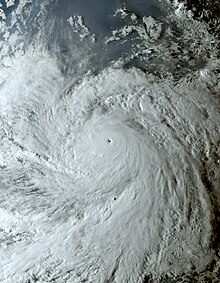
Jova nearing its peak intensity on September 7
FormedSeptember 4, 2023
Remnant lowSeptember 10, 2023
DissipatedSeptember 12, 2023
1-minute sustained (SSHWS/NWS)
Highest winds160 mph (260 km/h)
Lowest pressure929 mbar (hPa); 27.43 inHg
FatalitiesNone reported
Areas affectedWestern Mexico, Baja California peninsula, Southwestern United States

Part of the 2023 Pacific hurricane season
Hurricane Jova was a powerful Category 5 hurricane, the first Pacific hurricane to reach Category 5 strength since Willa in 2018, as well as one of the fastest intensifying tropical cyclones on record in the Eastern Pacific tropical cyclone basin.[1] Jova was the tenth named storm, seventh hurricane, fifth major hurricane[a] and first Category 5 hurricane of the 2023 Pacific hurricane season.
Jova originated from a tropical wave that entered the Pacific Ocean on September 1. The system briskly organized and became a tropical depression the following day. After brief inhibition by wind shear, Jova explosively organized over the next two days. It formed a prominent central dense overcast on September 5 and nascent eye feature, signaling its intensification into a hurricane. In a 24-hour period ending early on September 7, Jova's maximum sustained winds increased by 90 mph (150 km/h) to its peak of 160 mph (260 km/h) and a minimum pressure of 929 mbar (hPa; 27.43 inHg). This made it a Category 5 hurricane and was one of the five-fastest periods of intensification on record in the basin. Thereafter, an eyewall replacement cycle and decreasing sea surface temperatures caused the storm to steadily weaken. It fell below major hurricane status on September 8 and further weakened to a tropical storm on September 9. The total collapse of convection on September 10 marked its degeneration into a remnant low. The system later dissipated on September 12 as it opened up into a trough.
Jova's expansive cloud shield led to some rainfall in western states of Mexico with minor flooding occurring in Baja California Sur. Large waves and rip currents affected coastal areas from Sinaloa northward to the San Francisco Bay Area in California.

Meteorological history[edit]​

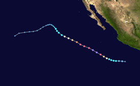
Map plotting the storm's track and intensity, according to the Saffir–Simpson scale
show
Map key
On August 31, 2023, the National Hurricane Center (NHC) began forecasting the possibility of tropical cyclogenesis off the southwest coast of Mexico.[3] The following day, a tropical wave crossed into the Pacific Ocean near El Salvador. Environmental conditions favored development and the NHC assessed a high likelihood of the system becoming a tropical cyclone within seven days.[4] Convective activity began organizing on September 3 as a broad area of low pressure coalesced.[5][6] On September 4, the system developed a well-defined surface circulation accompanied by a prominent banding feature to its west. Based on the improved organization, the NHC assessed the formation of Tropical Depression Eleven-E at 21:00 UTC. The environment ahead of the cyclone proved exceptionally conducive to rapid intensification with ample low-level moisture, low wind shear, and high sea surface temperatures. A deep-layer ridge anchored over northern Mexico steered the depression on a west to west-northwest course and would remain the dominant steering factor throughout the cyclone's duration.[7] While initially hampered by moderate wind shear early on September 5,[8] strengthening began later that day as upper-level outflow improved and deep convection blossomed over the system's center. Concurrent with the improved structure, the NHC estimated the system to have reached tropical storm intensity at 09:00 UTC, and the storm received the name Jova.[9]
Hurricane Jova rapidly intensifying over the course of the day on September 6
Rapid intensification ensued later on September 5 as a central dense overcast developed with tops reaching −112 °F (−80 °C). Imagery from the GPM Microwave Imager depicted the beginnings of a mid-level eyewall.[10][11] This trend continued into September 6 as cloud tops deepened to −130 °F (−90 °C) and Jova's eye became more defined on infrared and visible satellite imagery. Following this, the NHC upgraded Jova to a hurricane at 09:00 UTC.[12] Dramatic intensification continued throughout September 6 into the early hours of September 7. A well-defined 12 mi (19 km) wide pinhole eye formed within a symmetrical convective mass. Extensive lightning was detected within the eyewall by the GOES-16 Geostationary Lightning Mapper. Jova's intensification culminated at 03:00 UTC when it reached Category 5 hurricane status.[13] Jova's maximum sustained winds peaked at 160 mph (260 km/h) and its central pressure fell to 929 mbar (hPa; 27.43 inHg).[14] Within a 24-hour period Jova's winds increased by 90 mph (150 km/h), ranking it among the top six fastest intensification episodes in the Eastern Pacific basin on record.[13][15]
Upon reaching its peak on September 7, Jova began an eyewall replacement cycle (ERC) whereby its small eye is replaced by a larger core.[13] Its convective structure became less symmetric as convective bursts occurred along the south side of its center and overall cloud tops warmed.[16] By the latter half of the day weakening ensued with the hurricane's inner core collapsing as the ERC progressed and its eye becoming obscured by clouds.[17] The hurricane's structure steadily degraded with the inner and outer cores fragmenting as dry air was pulled into the circulation. Jova weakened below major hurricane status by 09:00 UTC on September 8.[18] Later that day, Jova crossed a sharp sea surface temperature gradient, with temperatures ahead of the hurricane dropping substantially. Banding features surrounding the hurricane began breaking apart at this time.[19] Early on September 9, Jova's eye completely disappeared and deep convection became limited to the western half of the storm, soon after, the system was downgraded to a tropical storm. Jova's movement shifted northwest as it reached the edge of the ridge that had been steering it west-northwest.[20][21] Throughout September 9 convection pulsated as Jova's weakening trend briefly reprieved,[22][23] however, the storm's convection continued its collapse on September 10 as Jova traversed 23 °C (73 °F) waters.[24] With the complete loss of convective activity later that day, Jova degenerated into a remnant low by 21:00 UTC marking the cessation of it being a tropical cyclone.[25] The remnants of Jova turned west-southwest and dissipated as it opened up into a trough on September 12.[26]

Preparations and impact[edit]​

Mexico[edit]​

Mexico's Servicio Meteorológico Nacional warned of heavy rains in Baja California Sur, Colima, Jalisco, Nayarit, and Sinaloa stemming from Jova's immense cloud shield. Waves of 6.6–13.1 ft (2–4 m) were expected along the coasts of Colima, Jalisco, Nayarit and Sinaloa.[27] Four beaches in Los Cabos closed due to dangerous conditions. Heavy rains in Baja California Sur swelled small streams, flooded roads, and caused some vehicles to become stranded.[28]

Southwestern United States[edit]​

Increased swells produced by Hurricane Jova on September 10 in Pacific Palisades, California
Moisture associated with Jova was pulled into the Southwestern United States by upper-level southwesterly flow,[29] reaching California on September 10. This led to increased humidity in coastal areas.[30][31] Minimal rainfall was recorded that day in the mountains of southern California. While Doppler weather radar returns showed rain in the region, dryer low- to mid-level air evaporated rainfall and led to virga.[32][33] Waves of 5–8 ft (1.5–2.4 m) and rip currents were forecast for south-facing beaches in Los Angeles and Ventura Counties as well as the Channel Islands. This prompted a high surf advisory for the region.[34][35] The San Francisco Bay Area farther north faced similar risks with rip currents and breaking waves up to 8 ft (2.4 m).[36] Five people were rescued in Ocean Beach, San Francisco, after being pulled to sea by rip currents on September 10.[37]

See also[edit]​

Notes[edit]​

  1. ^ A major hurricane is a storm that ranks as Category 3 or higher on the Saffir–Simpson hurricane wind scale.[2]

References[edit]​

  1. ^ Masters, Jeff; Henson, Bob (September 7, 2023). "Hurricane Lee rapidly intensifying, expected to hit Cat 5". New Haven, Connecticut: Yale Climate Connections. Archived from the original on September 7, 2023. Retrieved September 14, 2023.
  2. ^ Saffir–Simpson Hurricane Wind Scale. National Hurricane Center (Report). National Oceanic and Atmospheric Administration. May 23, 2013. Archived from the original on September 25, 2014. Retrieved May 6, 2019.
  3. ^ Cangialosi, John; Bucci, Lisa (August 31, 2023). "Seven-Day Tropical Weather Outlook". National Hurricane Center. Archived from the original on October 13, 2023. Retrieved September 11, 2023.
  4. ^ Brown, Daniel (September 1, 2023). "Seven-Day Tropical Weather Outlook". National Hurricane Center. Archived from the original on September 3, 2023. Retrieved September 11, 2023.
  5. ^ Zelinsky, David (September 3, 2023). "Seven-Day Tropical Weather Outlook". National Hurricane Center. Archived from the original on October 29, 2023. Retrieved September 11, 2023.
  6. ^ Reinhart, Brad (September 3, 2023). "Seven-Day Tropical Weather Outlook". National Hurricane Center. Archived from the original on September 5, 2023. Retrieved September 11, 2023.
  7. ^ Zelinsky, David (September 4, 2023). Tropical Depression Eleven-E Discussion Number 1 (Technical Discussion). National Hurricane Center. Archived from the original on September 7, 2023. Retrieved September 11, 2023.
  8. ^ Reinhart, Brad (September 5, 2023). Tropical Depression Eleven-E Discussion Number 2 (Technical Discussion). National Hurricane Center. Archived from the original on October 13, 2023. Retrieved September 11, 2023.
  9. ^ Pasch, Richard (September 5, 2023). Tropical Storm Jova Discussion Number 3 (Technical Discussion). National Hurricane Center. Archived from the original on September 7, 2023. Retrieved September 11, 2023.
  10. ^ Kelly, Larry; Blake, Eric (September 5, 2023). Tropical Storm Jova Discussion Number 5 (Technical Discussion). National Hurricane Center. Archived from the original on October 13, 2023. Retrieved September 11, 2023.
  11. ^ Berg, Robbie (September 5, 2023). Tropical Storm Jova Discussion Number 6 (Technical Discussion). National Hurricane Center. Archived from the original on October 13, 2023. Retrieved September 11, 2023.
  12. ^ Bucci, Lisa (September 6, 2023). Hurricane Jova Discussion Number 7 (Technical Discussion). National Hurricane Center. Archived from the original on September 7, 2023. Retrieved September 11, 2023.
  13. ^ Jump up to:a b c Reinhart, Brad (September 7, 2023). Hurricane Jova Discussion Number 10 (Technical Discussion). National Hurricane Center. Archived from the original on September 9, 2023. Retrieved September 11, 2023.
  14. ^ Reinhart, Brad (September 7, 2023). Hurricane Jova Advisory Number 10 (Report). National Hurricane Center. Archived from the original on September 7, 2023. Retrieved September 11, 2023.
  15. ^ Bartels, Meghan (September 8, 2023). "How Hurricanes Jova and Lee Rapidly Exploded into Category 5 Storms". Scientific American. Archived from the original on September 10, 2023. Retrieved September 11, 2023.
  16. ^ Bucci, Lisa (September 7, 2023). Hurricane Jova Discussion Number 11 (Technical Discussion). National Hurricane Center. Archived from the original on October 13, 2023. Retrieved September 11, 2023.
  17. ^ Kelly, Larry; Camposano, Samantha (September 7, 2023). Hurricane Jova Discussion Number 12 (Technical Discussion). National Hurricane Center. Archived from the original on October 3, 2023. Retrieved September 11, 2023.
  18. ^ Bucci, Lisa (September 8, 2023). Hurricane Jova Discussion Number 15 (Technical Discussion). National Hurricane Center. Archived from the original on October 3, 2023. Retrieved September 12, 2023.
  19. ^ Kelly, Larry; Brown, Daniel (September 7, 2023). Hurricane Jova Discussion Number 16 (Technical Discussion). National Hurricane Center. Archived from the original on October 13, 2023. Retrieved September 12, 2023.
  20. ^ Zelinsky, David (September 9, 2023). Hurricane Jova Discussion Number 18 (Technical Discussion). National Hurricane Center. Archived from the original on October 13, 2023. Retrieved September 12, 2023.
  21. ^ Roberts, Dave (September 9, 2023). Tropical Storm Jova Discussion Number 19 (Technical Discussion). National Hurricane Center. Archived from the original on October 13, 2023. Retrieved September 12, 2023.
  22. ^ Kelly, Larry (September 9, 2023). Tropical Storm Jova Discussion Number 21 (Technical Discussion). National Hurricane Center. Archived from the original on October 13, 2023. Retrieved September 12, 2023.
  23. ^ Pasch, Richard (September 10, 2023). Tropical Storm Jova Discussion Number 22 (Technical Discussion). National Hurricane Center. Archived from the original on October 13, 2023. Retrieved September 12, 2023.
  24. ^ Roberts, Dave (September 10, 2023). Tropical Storm Jova Discussion Number 23 (Technical Discussion). National Hurricane Center. Archived from the original on October 13, 2023. Retrieved September 12, 2023.
  25. ^ Kelly, Larry (September 10, 2023). Post-Tropical Cyclone Jova Discussion Number 25 (Technical Discussion). National Hurricane Center. Archived from the original on October 3, 2023. Retrieved September 12, 2023.
  26. ^ Rubio, Gladys (September 12, 2023). Tropical Weather Discussion for the eastern Pacific Ocean (Technical Discussion). Archived from the original on October 3, 2023. Retrieved September 12, 2023.
  27. ^ "El huracán Jova crece a categoría 5 y causa lluvias en el Pacífico mexicano" (in Spanish). Qué Pasa Media Network. EFE. September 7, 2023. Archived from the original on September 13, 2023. Retrieved September 11, 2023.
  28. ^ "Lluvias de huracán Jova ocasiona cierre de playas, vialidades y crecida de arroyos, en Los Cabos" (in Spanish). BCS Noticias. September 7, 2023. Archived from the original on September 13, 2023. Retrieved September 11, 2023.
  29. ^ Clemons, Marvin (September 8, 2023). "Pacific hurricane may bring rain to Las Vegas, but not a big threat". Las Vegas Review-Journal. Archived from the original on September 9, 2023. Retrieved September 11, 2023.
  30. ^ Rector, Kevin (September 10, 2023). "Blame Tropical Storm Jova in Pacific Ocean for Southern California's humid conditions". The Los Angeles Times. Archived from the original on September 11, 2023. Retrieved September 11, 2023.
  31. ^ National Weather Service Forecast Office in San Diego, California [@NWSSanDiego] (September 11, 2023). "Good Cloudy Morning! Tropical Cyclone #Jova is sending us some moisture leading to extensive cloud cover over SoCal this morning, which'll keep our highs down *a bit* today. Some areas may even get some light sprinkles (no t'storms expected) this morning and afternoon! #CAwx" (Tweet). Retrieved September 11, 2023 – via Twitter.
  32. ^ National Weather Service Forecast Office in San Diego, California [@NWSSanDiego] (September 11, 2023). "👀🌧️ Some moisture from Tropical Cyclone #Jova continues to stream in over SoCal with a bit of rain on the way! In some cases, you may see "rain" on radar at your given spot, but it's not actually raining. Why? Issuing a #NerdAlert 🤓for a lil science lesson below... #CAwx (1/4)" (Tweet). Retrieved September 11, 2023 – via Twitter.
  33. ^ National Weather Service Forecast Office in San Diego, California [@NWSSanDiego] (September 11, 2023). "Notice the air from ~550mb down has the red/green lines spaced out, indicating drier air. Lighter rain is evaporating in this layer before it hits the ground! Ways to overcome this: adding moisture into this layer via more rain/more moist air, or simply move up in elevation (3/4)" (Tweet). Retrieved September 11, 2023 – via Twitter.
  34. ^ Conybeare, Will (September 9, 2023). "Officials warn beachgoers of high surf, dangerous rip currents as tropical storm churns off SoCal coast". KTLA. Archived from the original on September 10, 2023. Retrieved September 11, 2023.
  35. ^ Blakinger, Kari (September 10, 2023). "Those heading to beaches amid heat are warned of treacherous rip currents and high surf". Archived from the original on September 10, 2023. Retrieved September 11, 2023.
  36. ^ Díaz, Gerry (September 8, 2023). "Tropical cyclone Jova to bring dangerous surf conditions to these California beaches". San Francisco Chronicle. Archived from the original on September 9, 2023. Retrieved September 11, 2023.
  37. ^ Sweeney, Don (September 11, 2023). "Rip current pulls 5 people, including 4 teens, out to sea, California rescuers say". The Sacramento Bee. Archived from the original on October 29, 2023. Retrieved September 11, 2023.

External links[edit]​

30px-Commons-logo.svg.png

Wikimedia Commons has media related to Hurricane Jova (2023).


show
Tropical cyclones of the 2023 Pacific hurricane season
Categories:
 
  • WTF
Reactions: Deleted member 45175

Attachments

  • 1698874336659.png
    1698874336659.png
    37.3 KB · Views: 0
  • +1
Reactions: Xangsane
1698874429066
 
  • JFL
Reactions: Xangsane

Rapid intensification​


From Wikipedia, the free encyclopedia
(Redirected from Rapid deepening)
This article is about tropical cyclones. For extratropical cyclones, see Explosive cyclogenesis.
Infrared satellite loop of Hurricane Jova in September 2023, as it underwent rapid intensification
In meteorology, rapid intensification is any process wherein a tropical cyclone intensifies dramatically in a short period of time. The United States National Hurricane Center defines rapid intensification as an increase in the maximum sustained winds of a tropical cyclone of at least 30 knots (35 mph; 55 km/h) in a 24-hour period.[1]

Necessary conditions[edit]​

External[edit]​

In order for rapid intensification to occur, several conditions must be in place. Water temperatures must be extremely warm (near or above 30 °C, 86 °F), and water of this temperature must be sufficiently deep that waves do not churn deeper cooler waters up to the surface. Wind shear must be low; when wind shear is high, the convection and circulation in the cyclone will be disrupted.[2] Dry air can also limit the strengthening of tropical cyclones.[3]

Internal[edit]​

Usually, an anticyclone in the upper layers of the troposphere above the storm must also be present for extremely low surface pressures to develop. This is because air must be converging towards the low pressure at the surface, which the requires the air to rise very rapidly in the eyewall of the storm due to conservation of mass, which in turn also requires a divergence of wind at the top of the troposphere. This process is aided by an upper-level anticyclone which helps efficiently channel this air away from the cyclone.[4] Hot towers have been implicated in tropical cyclone rapid intensification, though they have diagnostically seen varied impacts across basins.[5]
 
  • WTF
Reactions: Deleted member 45175
Send the prompt/text you used for it to give you these results.
 
  • +1
Reactions: Xangsane
16px-Symbol_category_class.svg.png
16px-Symbol_portal_class.svg.png
16px-People_icon.svg.png
 
  • +1
Reactions: Xangsane
i asked gpt to summarize this thread an it said:

cope till rope
 
  • +1
  • JFL
Reactions: Xangsane and Deleted member 45175

Similar threads

EPICTETVS
Replies
18
Views
302
DepigmentedBrownoid
DepigmentedBrownoid
cromagnon
Replies
35
Views
243
wishIwasSalludon
wishIwasSalludon
Georgeous
Replies
5
Views
161
Georgeous
Georgeous
justanothercurrycel
Replies
11
Views
553
PrinceofDarkness
PrinceofDarkness
Xangsane
Replies
120
Views
1K
therealme
therealme

Users who are viewing this thread

Back
Top