D
Deleted member 32485
Kraken
- Joined
- Jul 16, 2023
- Posts
- 3,688
- Reputation
- 3,559
Idk what to say. Just chilling in the break room rn
Follow along with the video below to see how to install our site as a web app on your home screen.

Note: this_feature_currently_requires_accessing_site_using_safari
Idk what to say. Just chilling in the break room rn
pat meIdk what to say. Just chilling in the break room rn
Jova = forever a meme storm not taken seriously by pro metsIdk what to say. Just chilling in the break room rn
What are mets?Jova = forever a meme storm not taken seriously by pro mets
MeterologistsWhat are mets?


@kebabMeterologists
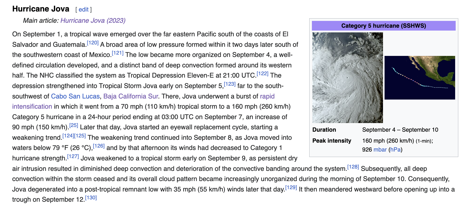
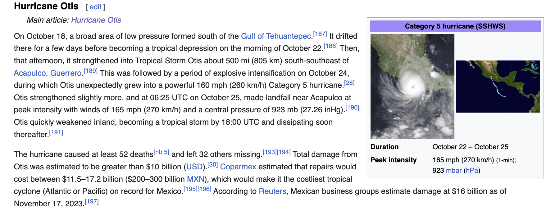
The National Hurricane Center denied Jova an upgrade when she clearly mogged Otis on camera:
View attachment 2717114View attachment 2717113
They gave her a muh "abbreviated report" which translates to "insignificant":
View attachment 2717116
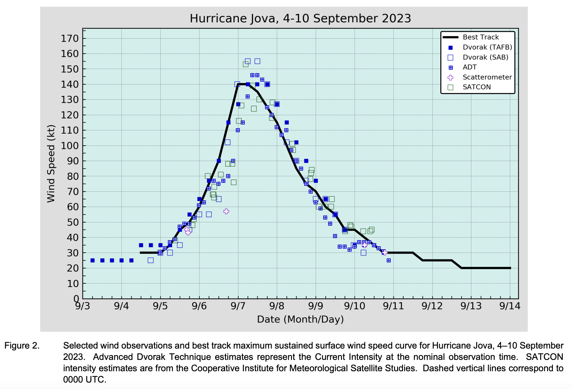
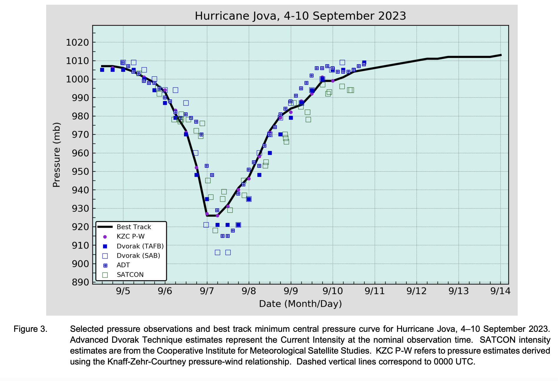
JFL at the discrepancies between the best track (what the mets have finalized) versus what was shown on camera/satellite/microwave *the squares):
View attachment 2717117View attachment 2717118
Jova was operationally (initially) 160mph/929 mbar and only got an upgrade to 160mph/926mbar DESPITE MOGGING TF OUT OF OTIS LOOKSWISE who was 165mph/923mbar
Niggas don't take storms with deathnic storms seriously either, rarely giving them upgrades compared to those with white names
Mulatta-passing triracial Latina mutt, curvy and bustywhat would joba look like if she was a person?

what would joba look like if she was a person?
Meterologists
The National Hurricane Center denied Jova an upgrade when she clearly mogged Otis on camera:
View attachment 2717114View attachment 2717113
They gave her a muh "abbreviated report" which translates to "insignificant":
View attachment 2717116
JFL at the discrepancies between the best track (what the mets have finalized) versus what was shown on camera/satellite/microwave *the squares):
View attachment 2717117View attachment 2717118
Jova was operationally (initially) 160mph/929 mbar and only got an upgrade to 160mph/926mbar DESPITE MOGGING TF OUT OF OTIS LOOKSWISE who was 165mph/923mbar
Niggas don't take storms with deathnic storms seriously either, rarely giving them upgrades compared to those with white names
mirin jovaTagging Jova enjoyers
@unknownducks @anthony111553 @edgemaxx @Egyptianmogger @Mainstream
mirin jova
Meterologists
The National Hurricane Center denied Jova an upgrade when she clearly mogged Otis on camera:
View attachment 2717114View attachment 2717113
They gave her a muh "abbreviated report" which translates to "insignificant":
View attachment 2717116
JFL at the discrepancies between the best track (what the mets have finalized) versus what was shown on camera/satellite/microwave *the squares):
View attachment 2717117View attachment 2717118
Jova was operationally (initially) 160mph/929 mbar and only got an upgrade to 160mph/926mbar DESPITE MOGGING TF OUT OF OTIS LOOKSWISE who was 165mph/923mbar
Niggas don't take storms with deathnic storms seriously either, rarely giving them upgrades compared to those with white names
#FREEJOVA
Meterologists
The National Hurricane Center denied Jova an upgrade when she clearly mogged Otis on camera:
View attachment 2717114View attachment 2717113
They gave her a muh "abbreviated report" which translates to "insignificant":
View attachment 2717116
JFL at the discrepancies between the best track (what the mets have finalized) versus what was shown on camera/satellite/microwave *the squares):
View attachment 2717117View attachment 2717118
Jova was operationally (initially) 160mph/929 mbar and only got an upgrade to 160mph/926mbar DESPITE MOGGING TF OUT OF OTIS LOOKSWISE who was 165mph/923mbar
Niggas don't take storms with deathnic storms seriously either, rarely giving them upgrades compared to those with white names
ALL HAIL JOVA#FREEJOVA
ALL HAIL JOVA
Yes!Is it jovaaaa?
Noooo, jovaAaaaaYes!
Yeah because she mogged tf out of otisNoooo, jovaAaaaa
JFL at the dalit who wrote this reportNoooo, jovaAaaaa
0#FREEJOVA
#JUSTICEFORJOVA
#NHCARECUCKS
#LISABUCCIISACUCK
#NHCAREDALITS
NIGGERS DIDN'T CHANGE IT EVEN THOUGH SHE BRUTALLY MOGGED OTIS ON CAMERA
JFL AT THESE NHC NIGGER FAGGOT CUCKS. JFL AT THE ABBREVIATED "DNRD" TROPICAL CYCLONE REPORT, LOOKS LIKE THEY CARE MORE ABOUT OTIS/LIDIA THAN JOVA WHO ONLY GETS MASTURBATED TO BY .ORG AUTISTS:
View attachment 2716847View attachment 2716911
"Peak Intensity and Minimum PressureThe peak intensity of 140 kt at 0000 UTC through 0600 UTC 7 September is supported by subjective Dvorak estimates from SAB and TAFB. While satellite intensity estimates continued to rise or were steady after the peak, this appears to be an artifact of the satellite classification constraints causing the estimates to lag during to the storm’s rapid intensification. The estimated minimum central pressure of 926 mb is based on the Knaff-Zehr-Courtney(KZC) pressure-wind relationship."
WEAKER PRESSURE (HIGHER PRESSURE) THAN OTIS
DESPITE MOGGING TF OUT OF OTIS
JFL AT THE NIGGER CUCKS @NHC

CUCKS
All hail Jova#FREEJOVA
#JUSTICEFORJOVA
#NHCARECUCKS
#LISABUCCIISACUCK
#NHCAREDALITS
NIGGERS DIDN'T CHANGE IT EVEN THOUGH SHE BRUTALLY MOGGED OTIS ON CAMERA
JFL AT THESE NHC NIGGER FAGGOT CUCKS. JFL AT THE ABBREVIATED "DNRD" TROPICAL CYCLONE REPORT, LOOKS LIKE THEY CARE MORE ABOUT OTIS/LIDIA THAN JOVA WHO ONLY GETS MASTURBATED TO BY .ORG AUTISTS:
View attachment 2716847View attachment 2716911
"Peak Intensity and Minimum PressureThe peak intensity of 140 kt at 0000 UTC through 0600 UTC 7 September is supported by subjective Dvorak estimates from SAB and TAFB. While satellite intensity estimates continued to rise or were steady after the peak, this appears to be an artifact of the satellite classification constraints causing the estimates to lag during to the storm’s rapid intensification. The estimated minimum central pressure of 926 mb is based on the Knaff-Zehr-Courtney(KZC) pressure-wind relationship."
WEAKER PRESSURE (HIGHER PRESSURE) THAN OTIS
DESPITE MOGGING TF OUT OF OTIS
JFL AT THE NIGGER CUCKS @NHC

CUCKS
i should hire you to find out odds, im currently betting on a music festival, your schizo illness may be of good use.
yi should hire you to find out odds, im currently betting on a music festival, your schizo illness may be of good use.
wtf is this

Read it all, 11/10 as usualJFL AT THESE NIGGERS
NATIONAL HURRICANE CENTERTROPICAL CYCLONE REPORT1HURRICANE JOVA(EP112023)4–10 September 2023Lisa BucciNational Hurricane Center1 February 2024GOES-18 INFRARED IMAGERY AT 0000 UTC 7 SEPTEMBER WHILE JOVA WAS AT PEAK INTENSITY. IMAGE COURTESY OF NOAA/NESDIS/STAR.Jova was a category 5 hurricane (on the Saffir-Simpson Hurricane Wind Scale) thatoccurred in the eastern Pacific ocean and did not affect land.1 This is an abbreviated Tropical Cyclone Report since there were no coastal watches or warnings issuedand no direct fatalities reported in association with Jova.HURRICANE JOVA 2Hurricane Jova4–10 SEPTEMBER 2023BEST TRACKHurricane Jova is notable for its impressive rapid intensification over a 48-h period, goingfrom a 30-kt tropical depression on 0000 UTC 5 September to its peak intensity of 140-kt on 0000UTC 7 September (cover photo). The “best track2” positions and intensities for Hurricane Jovaare listed in Table 1. The best track chart of Jova’s path is given in Fig. 1, with the wind andpressure histories along with available observations3 shown in Figs. 2 and 3, respectively.There were no ship or buoy reports of tropical-storm-force winds associated with Jova.OriginThe origins of Jova are from an easterly wave that exited the western coast of Africa on23 August, crossed the Windward Islands on 29‒30 August and crossed Central America on 1‒2 September. A tropical depression formed over the eastern Pacific on 4 September.Peak Intensity and Minimum PressureThe peak intensity of 140 kt at 0000 UTC through 0600 UTC 7 September is supportedby subjective Dvorak estimates from SAB and TAFB. While satellite intensity estimates continuedto rise or were steady after the peak, this appears to be an artifact of the satellite classificationconstraints causing the estimates to lag during to the storm’s rapid intensification.The estimated minimum central pressure of 926 mb is based on the Knaff-Zehr-Courtney(KZC) pressure-wind relationship.2 A digital record of the complete best track, including wind radii, can be found on line atftp://ftp.nhc.noaa.gov/atcf. Data for the current year’s storms are located in the btk directory, while previousyears’ data are located in the archive directory.3 Observations include subjective satellite-based Dvorak technique intensity estimates from the TropicalAnalysis and Forecast Branch (TAFB) and the Satellite Analysis Branch (SAB), objective Advanced DvorakTechnique (ADT) estimates and Satellite Consensus (SATCON) estimates from the Cooperative Institutefor Meteorological Satellite Studies/University of Wisconsin-Madison. Data and imagery from NOAA polarorbiting satellites including the Advanced Microwave Sounding Unit (AMSU), the NASA Global PrecipitationMission (GPM), the European Space Agency’s Advanced Scatterometer (ASCAT), and DefenseMeteorological Satellite Program (DMSP) satellites, among others, were also useful in constructing the besttrack of Jova.HURRICANE JOVA 3CASUALTY AND DAMAGE STATISTCSThere were no reports of damage or casualties associated with Jova.FORECAST AND WARNING VERIFICATIONTable 2 provides the number of hours in advance of formation with the first NHC TropicalWeather Outlook (TWO) forecast in each likelihood category. Figure 4 shows composites of 7-day TWO genesis areas for each category prior to the formation of Jova. Jova’s genesis locationoccurred within all potential formation areas depicted by NHC. However, the forecast lead timefor genesis was short, with the system first introduced in the TWO only 90 h before formation.The 48-h probability did not reach the high category until 6 h prior to genesis.A verification of NHC official track forecasts for Jova is given in Table 3a. Official trackforecast errors were lower than the mean official errors for the previous 5-yr period for all forecasthours except 72 h. A homogeneous comparison of the official track errors with selected guidancemodels is given in Table 3b.A verification of NHC official intensity forecasts for Jova is given in Table 4a. Officialintensity forecast errors were greater than the mean official errors for the previous 5-yr period forall forecast hours, largely due to NHC’s forecast not anticipating the magnitude of the storm’srapid intensification and subsequent weakening. A homogeneous comparison of the officialintensity errors with selected guidance models is given in Table 4b. Of the available guidance,the statistical models (including LGEM and DSHP) performed better than the official forecast,particularly in the short-term forecast period, because they more accurately captured Jova’s rapidintensification (Fig. 5). Several of the simple and corrected consensus aids (HCCA, ICON, etc.)had lower intensity errors than the NHC forecast throughout most, if not all, of the forecast period.Those guidance aids also predicted Jova’s rapid weakening phase especially well. Regional andglobal dynamical models largely missed the rapid intensification event, though those aids tendedto have errors lower than the official forecast errors in the long-term forecast period (72-96 h).There were no coastal watches or warnings issued for Jova.HURRICANE JOVA 4Table 1. Best track for Hurricane Jova, 4‒10 September 2023.Date/Time(UTC)Latitude(°N)Longitude(°W)Pressure(mb)Wind Speed(kt) Stage04 / 1200 12.2 102.8 1007 30 low04 / 1800 12.3 103.8 1007 30 tropical depression05 / 0000 12.4 104.9 1006 30 "05 / 0600 12.4 105.9 1004 35 tropical storm05 / 1200 12.5 106.7 1001 45 "05 / 1800 12.7 107.5 998 50 "06 / 0000 13.0 108.2 993 60 "06 / 0600 13.3 109.0 981 75 hurricane06 / 1200 13.9 110.0 972 90 "06 / 1800 14.6 111.1 953 115 "07 / 0000 15.3 112.4 926 140 "07 / 0600 16.1 113.7 926 140 "07 / 1200 16.8 115.0 932 135 "07 / 1800 17.4 116.6 941 125 "08 / 0000 18.0 117.9 947 115 "08 / 0600 18.8 119.1 959 100 "08 / 1200 19.5 120.6 972 85 "08 / 1800 20.1 121.9 980 75 "09 / 0000 20.7 123.2 984 70 "09 / 0600 21.2 124.2 986 60 tropical storm09 / 1200 22.0 125.2 992 55 "09 / 1800 22.6 125.8 999 45 "10 / 0000 23.3 126.2 999 45 "10 / 0600 23.8 126.6 1001 40 low10 / 1200 24.2 127.0 1004 35 "10 / 1800 24.5 127.4 1005 30 "11 / 0000 24.7 127.7 1006 30 "11 / 0600 24.8 128.2 1007 30 "11 / 1200 24.7 128.6 1008 30 "HURRICANE JOVA 5Date/Time(UTC)Latitude(°N)Longitude(°W)Pressure(mb)Wind Speed(kt) Stage11 / 1800 24.6 129.0 1009 25 "12 / 0000 24.4 129.5 1010 25 "12 / 0600 23.9 130.5 1011 25 "12 / 1200 23.3 131.4 1011 25 "12 / 1800 22.7 132.5 1012 20 "13 / 0000 22.4 133.8 1012 20 "13 / 0600 22.3 135.1 1012 20 "13 / 1200 22.1 136.7 1012 20 "13 / 1800 21.8 138.6 1012 20 "14 / 0000 20.9 140.0 1013 20 "14 / 0600 dissipated07 / 0000 15.3 112.4 926 140 minimum pressure &maximum windsHURRICANE JOVA 6Table 2. Number of hours in advance of formation associated with the first NHC TropicalWeather Outlook forecast in the indicated likelihood category. Note that thetimings for the “Low” category do not include forecasts of a 0% chance of genesis.Hours Before Genesis48-Hour Outlook 168-Hour OutlookLow (<40%) 60 90Medium (40%-60%) 30 78High (>60%) 6 66Table 3a. NHC official (OFCL) and climatology-persistence skill baseline (OCD5) trackforecast errors (n mi) for Hurricane Jova, 4‒10 September 2023. Mean errors forthe previous 5-yr period are shown for comparison. Official errors that are smallerthan the 5-yr means are shown in boldface type.Forecast Period (h)12 24 36 48 60 72 96 120OFCL 19.7 30.0 39.8 48.9 64.0 80.4 86.1 73.6OCD5 33.5 62.2 94.8 137.1 205.9 281.2 370.2 408.2Forecasts 20 18 16 14 12 10 6 2OFCL (2018-22) 22.1 34.0 45.4 56.0 70.9 78.7 100.5 117.8OCD5 (2018-22) 36.7 73.4 114.0 156.9 193.2 244.5 317.0 376.0HURRICANE JOVA 7Table 3b. Homogeneous comparison of selected track forecast guidance models (in n mi)for Hurricane Jova, 4‒10 September 2023. Errors smaller than the NHC officialforecast are shown in boldface type. The number of official forecasts shown herewill generally be smaller than that shown in Table 3a due to the homogeneityrequirement.Model IDForecast Period (h)12 24 36 48 60 72 96 120OFCL 16.2 27.8 42.0 54.0 68.0 81.9 78.1OCD5 29.1 61.8 106.5 170.3 253.5 339.7 450.2GFSI 17.9 35.1 54.1 73.1 84.8 101.4 66.5HWFI 18.2 36.7 60.8 78.1 90.3 114.6 120.3HMNI 23.4 39.9 51.5 63.2 60.5 69.1 69.0HFAI 22.4 43.2 63.2 76.6 86.2 89.6 109.5HFBI 22.3 43.0 59.1 72.9 66.9 58.2 41.5EGRI 22.7 45.9 79.0 116.8 159.1 208.8 332.5EMXI 17.4 23.3 32.9 48.0 60.9 79.1 105.6NVGI 21.4 26.4 37.7 52.8 72.9 88.5 86.1CMCI 22.4 42.1 59.5 70.9 85.7 85.5 81.5CTCI 22.5 44.3 61.9 86.0 97.0 126.8 108.3TVCE 16.8 31.9 47.6 62.2 73.6 89.7 97.1TVCX 17.0 31.2 46.5 61.6 72.7 89.2 91.6GFEX 14.7 25.8 41.2 56.1 70.6 87.7 85.7TVDG 17.3 32.0 47.2 61.2 76.2 95.1 109.7HCCA 16.8 26.9 38.6 48.4 57.7 63.7 83.9FSSE 16.0 25.6 37.4 43.0 53.7 75.2 85.6AEMI 17.8 34.8 53.1 75.3 86.6 94.9 97.2TABS 25.8 46.0 59.9 82.3 123.5 148.8 57.0TABM 19.4 29.1 43.9 69.9 106.5 123.1 60.1TABD 18.3 28.3 46.2 74.2 104.5 127.4 58.7Forecasts 16 14 12 10 8 6 2 0HURRICANE JOVA 8Table 4a. NHC official (OFCL) and climatology-persistence skill baseline (OCD5) intensityforecast errors (kt) for Hurricane Jova, 4‒10 September 2023. Mean errors for theprevious 5-yr period are shown for comparison. Official errors that are smallerthan the 5-yr means are shown in boldface type.Forecast Period (h)12 24 36 48 60 72 96 120OFCL 9.0 17.8 25.9 32.1 32.1 26.0 24.2 25.0OCD5 10.7 20.7 30.0 37.5 39.2 34.8 15.8 17.5Forecasts 20 18 16 14 12 10 6 2OFCL (2018-22) 5.4 8.9 11.0 12.8 14.3 15.8 17.0 17.6OCD5 (2018-22) 6.9 12.1 15.9 18.6 18.7 21.0 22.3 22.1HURRICANE JOVA 9Table 4b. Homogeneous comparison of selected intensity forecast guidance models (in kt)for Hurricane Jova, 4‒10 September 2023. Errors smaller than the NHC officialforecast are shown in boldface type. The number of official forecasts shown herewill generally be smaller than that shown in Table 4a due to the homogeneityrequirement.Model IDForecast Period (h)12 24 36 48 60 72 96 120OFCL 9.4 18.4 25.4 26.7 27.5 26.9 25.0OCD5 11.2 22.3 30.5 33.2 32.6 30.4 21.0HWFI 13.3 22.6 30.9 28.9 21.2 13.5 3.8HMNI 11.9 22.1 28.3 25.9 20.4 15.4 2.8HFAI 11.6 22.1 30.1 27.2 18.5 9.4 4.5HFBI 12.4 22.1 28.7 26.7 18.6 11.8 4.0DSHP 8.6 16.4 24.9 29.6 30.2 33.2 42.8LGEM 7.2 13.6 19.5 21.9 23.3 26.1 26.8ICON 9.6 18.3 24.4 24.1 19.8 16.4 16.5IVCN 10.1 19.3 26.2 24.0 16.8 11.2 11.0IVDR 10.7 20.6 28.4 26.2 18.3 10.2 7.0CTCI 10.7 19.9 27.5 24.8 15.7 10.4 7.2GFSI 14.0 28.1 39.0 40.2 34.9 23.1 9.0EMXI 16.5 31.9 43.4 44.3 35.3 22.9 6.8HCCA 9.2 15.8 20.6 18.0 9.0 5.5 7.2FSSE 9.6 19.2 28.4 27.5 18.8 13.4 20.0Forecasts 18 16 14 12 10 8 4 0HURRICANE JOVA 10Figure 1. Best track positions for Hurricane Jova, 4‒10 September 2023.HURRICANE JOVA 11Figure 2. Selected wind observations and best track maximum sustained surface wind speed curve for Hurricane Jova, 4‒10 September2023. Advanced Dvorak Technique estimates represent the Current Intensity at the nominal observation time. SATCONintensity estimates are from the Cooperative Institute for Meteorological Satellite Studies. Dashed vertical lines correspond to0000 UTC.HURRICANE JOVA 12Figure 3. Selected pressure observations and best track minimum central pressure curve for Hurricane Jova, 4‒10 September 2023.Advanced Dvorak Technique estimates represent the Current Intensity at the nominal observation time. SATCON intensityestimates are from the Cooperative Institute for Meteorological Satellite Studies. KZC P-W refers to pressure estimates derivedusing the Knaff-Zehr-Courtney pressure-wind relationship. Dashed vertical lines correspond to 0000 UTC.HURRICANE JOVA 13Figure 4. Composites of 7-day tropical cyclone genesis areas depicted in NHC’s Tropical Weather Outlooks prior to the formation of Jovafor (a) all probabilistic genesis categories, (b) the low (<40%) category, (c) medium (40–60%) category, and (d) high (>60%)category. The location of genesis is indicated by the black star.HURRICANE JOVA 14Figure 5. (Upper left) NHC official intensity forecasts (dashed blue lines) from 0000 UTC 5 September to 1800 UTC 9 September. (Upperright) Interpolated HAFS-A intensity forecasts (dotted dark green), (lower left) LGEM (dotted dark magenta), and (lower right)ICON (dotted cyan) are shown for the same times. The best track is depicted by the black line with markers shown every 6hours.
Read it all, 11/10 as usual

IT'S OFFICIAL: OTIS MOGS JOVA
THE NHC DECLARES TODAY THAT OTIS MOGS JOVA TO THE SLUMS OF ACAPULCO AND BACK. CAGING AT THE FACT THE NHC GAVE JOVA A SLOPPILY-PRESENTED REPORT. OTIS: https://www.nhc.noaa.gov/data/tcr/EP182023_Otis.pdf JOVA: https://www.nhc.noaa.gov/data/tcr/EP112023_Jova.pdflooksmax.org