Xangsane
squishy squishy!
- Joined
- Jun 11, 2021
- Posts
- 160,607
- Reputation
- 140,208


000
WTNT43 KNHC 071459
TCDAT3
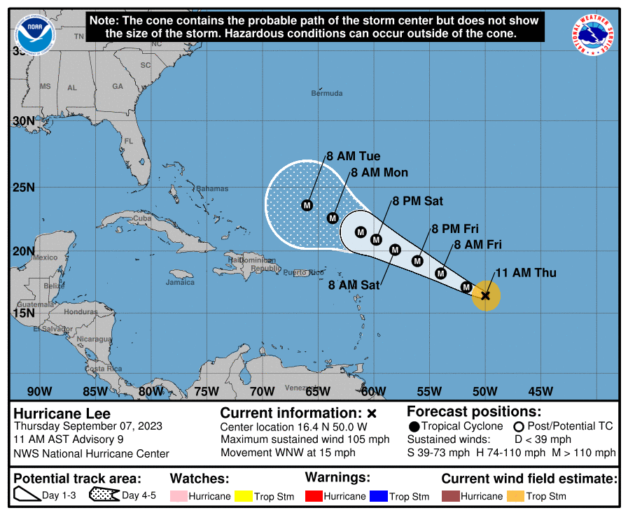
Hurricane Lee Discussion Number 9
NWS National Hurricane Center Miami FL AL132023
1100 AM AST Thu Sep 07 2023
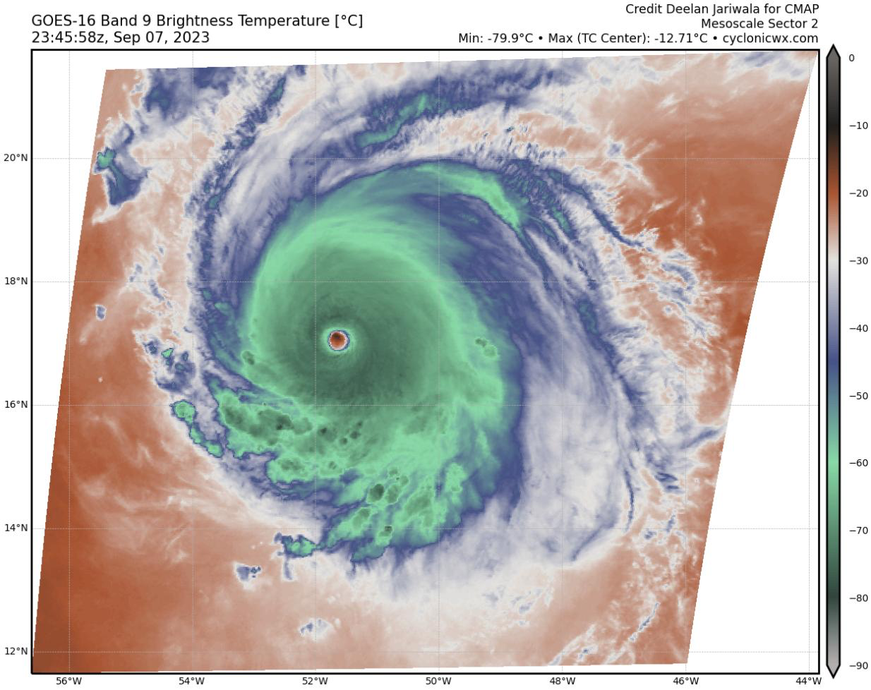
Lee is rapidly intensifying. Early this morning, a well-defined
low-to mid-level eye was observed in microwave imagery, a signal
that is often a precursor rapid intensification (RI). Since then,
Lee has developed an eye in visible and infrared imagery, with
subjective Dvorak Data-T estimates quickly increasing to as high as
5.5 during the past hour or so. Satellite classifications supported
an intensity of around 80 kt at 1200 UTC, but given the significant
improvement in Lee's appearance since then, the advisory intensity
is set at 90 kt.
The track guidance remains in very good agreement on the forecast
for Lee through the weekend and confidence in the track forecast is
high. Lee should continue west-northwestward, gradually slowing its
forward speed, moving along the southern periphery of a subtropical
ridge over the central Atlantic. Confidence continues to increase
that Lee will pass north of the northern Leeward Islands, though
swells associated with Lee will affect the islands starting
tomorrow. By the end of the forecast, the uncertainty is a little
higher, with the hurricane models (HAFS, HWRF) generally being
farther south than the global models. Very small changes were made
to the NHC track forecast, which is between the HCCA and simple
consensus aids.
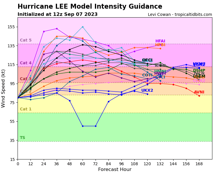
As stated above, RI is occuring, and will likely continue today. The
question doesn't appear to be if RI continues, but rather how
strong Lee will get, and how quickly will it get there. Many of the
models are calling for remarkable rates of intensification, beyond
rates normally seen with model forecasts. Both HAFS models forecast
Lee to exceed 150 kt within the next 2 days, and even HCCA brings
the hurricane above the category 5 threshold. The NHC intensity
forecast has been shifted significantly higher, but is actually
within the guidance envelope. It should be stressed that internal
dynamics (eyewall replacement cycles) will become a factor with the
maximum strength of Lee as it becomes a major hurricane. This
is almost certain to lead to fluctuations in intensity that are
beyond our ability to forecast at these lead times. Hurricane Hunter
aircraft are scheduled to investigate Lee beginning this evening and
overnight, which should provide extremely useful information about
Lee's intensity during the coming days.
KEY MESSAGES:
1. Lee is forecast to become a major hurricane later today, with
its core moving north of the northern Leeward Islands, the Virgin
Islands, and Puerto Rico this weekend and early next week. The
potential for tropical storm conditions to occur in the islands is
decreasing, but residents there should continue to monitor updates
on Lee.
2. Swells generated by Lee are expected to reach portions of the
Lesser Antilles on Friday, and the British and U.S. Virgin Islands,
Puerto Rico, Hispaniola, the Bahamas, and Bermuda this weekend.
These swells are likely to cause life-threatening surf and rip
current conditions.
FORECAST POSITIONS AND MAX WINDS
INIT 07/1500Z 16.4N 50.0W 90 KT 105 MPH
12H 08/0000Z 17.1N 51.7W 115 KT 130 MPH
24H 08/1200Z 18.2N 54.0W 130 KT 150 MPH
36H 09/0000Z 19.2N 56.1W 140 KT 160 MPH
48H 09/1200Z 20.1N 58.1W 140 KT 160 MPH
60H 10/0000Z 20.9N 59.8W 135 KT 155 MPH
72H 10/1200Z 21.5N 61.2W 135 KT 155 MPH
96H 11/1200Z 22.6N 63.7W 125 KT 145 MPH
120H 12/1200Z 23.6N 66.0W 120 KT 140 MPH
$$
Forecaster J. Barrett
@slop slinger @uselessmentalcel @howtallareyou
Last edited:


