
Xangsane
^ Sheboons consider these lot white
- Joined
- Jun 11, 2021
- Posts
- 152,285
- Reputation
- 129,534
Hurricane Lee  | |||||||||||||||||||||||||||||
|
Follow along with the video below to see how to install our site as a web app on your home screen.

Note: this_feature_currently_requires_accessing_site_using_safari
| Hurricane Lee | |||||||||||||||||||||||||||||
|
rich people can just move to another of their propertiesView attachment 2431636View attachment 2431634
Hurricane Lee
...TROPICAL STORM WARNING ISSUED FOR CAPE COD, MARTHA'S VINEYARD, AND NANTUCKET... ...DANGEROUS SURF AND RIP CURRENT CONDITIONS AFFECTING MUCH OF THE EAST COAST OF THE UNITED STATES...
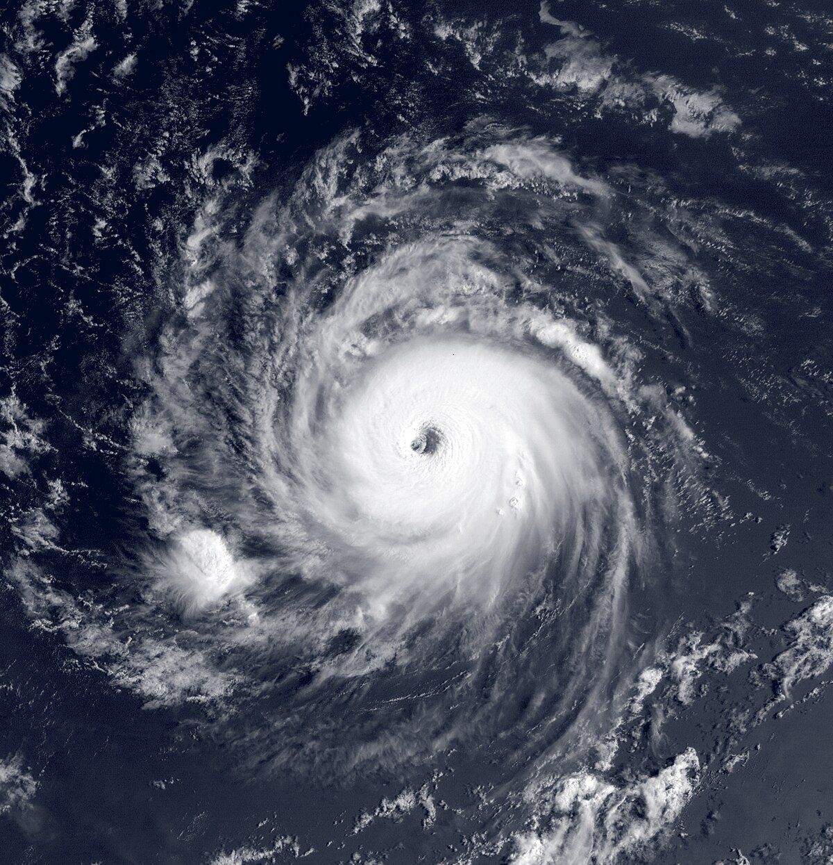
11:00 AM AST Thu Sep 14
Location: 30.4°N 68.3°W
Moving: N at 14 mph
Min pressure: 956 mb
Max sustained: 90 mphPublic
Advisory
#37
1100 AM ASTAviso
Publico*
#37
1100 AM ASTForecast
Advisory
#37
1500 UTCForecast
Discussion
#37
1100 AM ASTWind Speed
Probabilities
#37
1500 UTCNWS Local
Products
1151 AM EDTUS Watch/
Warning
1053 AM EDT
nobody cares you retarded creature
@Xangsane I have a job for you. You must find the morphed woman version of Colton haynes that you used to ahve in your pfp 2 years ago.
It would be funny to see Lee eat the richrich people can just move to another of their properties
only poor people suffer
no jfl it wasn't this pic
It was....no jfl it wasn't this pic
Why?It was....
How many fathers, right, how many sons, yeah, have you cut, killed, murdered, fucking butchered, innocent and guilty and sent them straight to fucking hell ain' ya? Just like me! You fucking stand there. You judging me, stand there, and talk to me about crossing some fucking line?
How many fathers, right, how many sons, yeah, have you cut, killed, murdered, fucking butchered, innocent and guilty and sent them straight to fucking hell ain' ya? Just like me! You fucking stand there. You judging me, stand there, and talk to me about crossing some fucking line?

do you like jidion's videos xangsane? or you don't watch him
No, but what are they about?do you like jidion's videos xangsane? or you don't watch him
mostly about teaseing karens and the police.No, but what are they about?
What happened to him?mostly about teaseing karens and the police.
What happened to him?
YI got excited
"Ur anus is a planet"Y
I'll have a look!
Do you think Lee would mog enough?I just want it to be bad enough I get days pff in school
KEY MESSAGES:
1. Tropical storm conditions, heavy rainfall, and high surf will
continue to impact Bermuda through Friday morning, and a Tropical
Storm Warning is in effect for the island.
2. Hurricane conditions and coastal flooding are possible in
portions of eastern Maine, southern New Brunswick, and western Nova
Scotia on Saturday, and a Hurricane Watch is in effect for that
area. Tropical storm conditions are expected on Cape Cod, Martha's
Vineyard, and Nantucket where a Tropical Storm Warning is now in
effect. Tropical storm conditions are possible elsewhere across New
England and Atlantic Canada within the Tropical Storm Watch areas.
3. Heavy rainfall from Lee may produce localized urban and small
stream flooding across eastern New England and into portions of New
Brunswick and Nova Scotia from Friday night into Saturday night.
4. There is the potential for life-threatening storm surge flooding
in portions of southeastern Massachusetts, including Cape Cod and
Nantucket, late Friday and Saturday, where a Storm Surge Watch is in
effect.
FORECAST POSITIONS AND MAX WINDS
INIT 14/1500Z 30.4N 68.3W 80 KT 90 MPH
12H 15/0000Z 32.2N 68.0W 75 KT 85 MPH
24H 15/1200Z 35.0N 67.2W 70 KT 80 MPH
36H 16/0000Z 38.2N 66.6W 70 KT 80 MPH
48H 16/1200Z 41.5N 66.5W 65 KT 75 MPH
60H 17/0000Z 44.0N 66.1W 55 KT 65 MPH...POST-TROP/EXTRATROP
72H 17/1200Z 47.0N 63.6W 45 KT 50 MPH...POST-TROP/EXTRATROP
96H 18/1200Z 52.6N 52.2W 35 KT 40 MPH...POST-TROP/EXTRATROP
120H 19/1200Z...DISSIPATED
$$
Forecaster Pajeet
I just want it to be bad enough I get days pff in school
The long-range GFS has a 1996 scenario with Hurricane Lee taking a track similar to Hurricane Edouard '96 and a new system slamming into North Carolina as the worst strike since Hurricane Fran '96.
This season just feels so much like '96, especially with that constant wave train.
Nah I don’t think it will its kinda far im in new jersey but ill tell u if it doesDo you think Lee would mog enough?
Thanks bhai, please let me know.Nah I don’t think it will its kinda far im in new jersey but ill tell u if it does
The long-range GFS has a 1996 scenario with Hurricane Lee taking a track similar to Hurricane Edouard '96 and a new system slamming into North Carolina as the worst strike since Hurricane Fran '96.
This season just feels so much like '96, especially with that constant wave train.
Hurricane Edouard (1996) - Wikipedia
en.wikipedia.org
I just want it to be bad enough I get days pff in school
Lee to Cape Cod/Nantucket/Martha's Vineyard old money chadsThe long-range GFS has a 1996 scenario with Hurricane Lee taking a track similar to Hurricane Edouard '96 and a new system slamming into North Carolina as the worst strike since Hurricane Fran '96.
This season just feels so much like '96, especially with that constant wave train.


