[MOG BATTLE] Who will mog harder? Jova or Lee?

Who will mog harder?


  • Total voters
    8
Xangsane

Xangsane

^ Sheboons consider these lot white
Joined
Jun 11, 2021
Posts
152,205
Reputation
129,455
Title.

Jova
93E gefs latest
93E intensity latest 1
Screenshot 20230904 112106


Lee
95L gefs latest
95L intensity latest 1
Ecens 2023 09 04 00 Z 192 28 686 288 491 19 416 300 145 MSLP Surface tracks lows
3622856 Screenshot 20230902 151732


Last edited:
Is this about which name is better?


Or did you upload pics that I just can't see?
 
  • +1
Reactions: Xangsane
Ok I can see the pics now
Lee mogs
 
  • +1
Reactions: Xangsane
  • +1
Reactions: Deleted member 30942
@Trilogy
 
  • +1
Reactions: Xangsane
Because the name sounds better
And it's reaching cat 5 intensity
Whereas jova in only at cat 4
That's one model prediction which could be an outlier. Both Jova and Lee are expected to peak at Category 4 but I won't be surprised if Lee mogs Jova and even peaks at a category 5 based on Lee's previous model runs compared to Jova's
 
  • +1
Reactions: Deleted member 30942
That's one model prediction which could be an outlier. Both Jova and Lee are expected to peak at Category 4 but I won't be surprised if Lee mogs Jova and even peaks at a category 5 based on Lee's previous model runs compared to Jova's
I see
Lee still sounds cooler tho
And even after it's peak it looks like it will go strong
Jova drops hard after getting to category 4
 
  • +1
Reactions: Xangsane
I see
Lee still sounds cooler tho
And even after it's peak it looks like it will go strong
Jova drops hard after getting to category 4
Why does Lee sound cooler?

Lee is expected to be a long tracker
 
  • +1
Reactions: Deleted member 30942
Why does Lee sound cooler?

Lee is expected to be a long tracker
Jova is a very lame name
Lee just sounds better

I could see someone named lee being a mogger
But not jova
 
  • +1
Reactions: Xangsane
Jova is a very lame name
Lee just sounds better

I could see someone named lee being a mogger
But not jova
Remember this lil nigga?

3623032 RwBY0H1

Jovan Humberto Andrade

Jovan H Andrade

Jovan Andrade

June 22 1986

aka


the lategreat bbctakeover

aka


bbctakeover

aka


supportlocalsluts

aka


jankinoff
 
  • +1
Reactions: Deleted member 30942
  • +1
Reactions: Xangsane
The names cooler
My prediction is that future Lee will be the system of the year ACE wise and will surpass the 22.6 of Franklin. I can see it reaching 40-45 ACE units.

@slop slinger
 
  • +1
Reactions: Deleted member 30942
My prediction is that future Lee will be the system of the year ACE wise and will surpass the 22.6 of Franklin. I can see it reaching 40-45 ACE units.

@slop slinger
Brutal
It's gonna destroy everything
 
  • So Sad
Reactions: Xangsane
My prediction is that future Lee will be the system of the year ACE wise and will surpass the 22.6 of Franklin. I can see it reaching 40-45 ACE units.

@slop slinger
I agree
 
  • +1
Reactions: Xangsane
@Endoplasmic82 why Jova?
 
Idk I didn’t read it
 
  • +1
Reactions: Xangsane
Idk I didn’t read it
@slop slinger @howtallareyou

IT BEGAN FOR JOVACELS

1693860906248

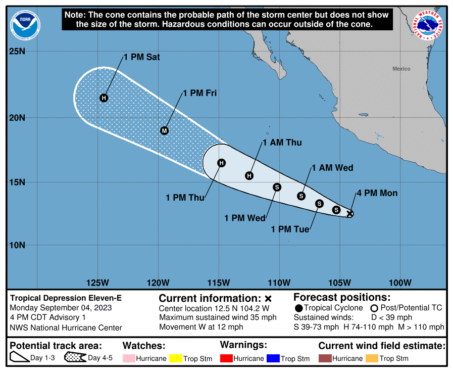
Tropical Depression Eleven-E Forecast Discussion​


000
WTPZ41 KNHC 042037
TCDEP1

Tropical Depression Eleven-E Discussion Number 1
NWS National Hurricane Center Miami FL EP112023
400 PM CDT Mon Sep 04 2023

Recent visible satellite imagery indicates that the disturbance
located south of the southwestern coast of Mexico (93E) has
developed a well-defined circulation. In addition, a prominent band
of deep convection has formed around its western half. The latest
Dvorak classification Data-T from TAFB is a 2.0, which corresponds
to 30 kt. Based on the available data, the system has been
classified as Tropical Depression Eleven.

The depression is moving westward, with an estimated forward speed
of 10 kt. While all models agree that the cyclone will head
generally west-northwestward for the next 5 or more days, moving
well south and west of Mexico, there is substantial disagreement on
its forward speed. The main source of this uncertainty appears to be
differences in the strength of the primary steering mechanism
influencing the depression, a deep ridge centered over northern
Mexico and the southwestern U.S. that extends over the eastern
Pacific. The stronger the ridge, the faster the cyclone will move.
The uncertainty in the track forecast is much higher than normal by
the end of the forecast, with even the consensus models relatively
far apart. At day 5, the gap between HCCA and TVCN is more than 150
n mi. As a course of least regret, the NHC forecast doesn't favor
any one model or consensus aid, generally staying between the simple
and corrected consensus tracks.

The environment looks very conducive for strengthening, possibly
significantly so. SHIPS-derived shear is forecast to be near or
below 10 kt through day 5, with plenty of moisture and warm SSTs
available as well. It will likely take a day or so for the
depression to get sufficiently organized to take advantage of this
environment, so only slow strengthening is forecast for the first 24
h. Looking beyond that, the SHIPS-RII and DTOPS rapid
intensification (RI) probabilities for 65kt/72 h are both above 60
percent. The NHC forecast explicitly shows RI starting at 36 h and
continuing through 72 h. While there is spread at just how strong
the cyclone will get, most models suggest its peak will come between
72 and 96 h, so a peak intensity higher than what the NHC forecast
shows is definitely possible. Beginning at 96 h, the cyclone should
begin to quickly spin down as it moves over cooler waters.


FORECAST POSITIONS AND MAX WINDS

INIT 04/2100Z 12.5N 104.2W 30 KT 35 MPH
12H 05/0600Z 12.8N 105.3W 35 KT 40 MPH
24H 05/1800Z 13.3N 106.7W 40 KT 45 MPH
36H 06/0600Z 13.9N 108.2W 50 KT 60 MPH
48H 06/1800Z 14.6N 110.2W 60 KT 70 MPH
60H 07/0600Z 15.5N 112.5W 80 KT 90 MPH
72H 07/1800Z 16.5N 114.8W 95 KT 110 MPH
96H 08/1800Z 19.0N 119.5W 100 KT 115 MPH
120H 09/1800Z 21.5N 124.5W 75 KT 85 MPH

$$
Forecaster D. Zelinsky
 
WATCH LEE MOG LORENZO AND SAM TO BIKINI BOTTOM AND BACK

 
@slop slinger @howtallareyou

IT BEGAN FOR JOVACELS

View attachment 2416211

Tropical Depression Eleven-E Forecast Discussion​


000
WTPZ41 KNHC 042037
TCDEP1

Tropical Depression Eleven-E Discussion Number 1
NWS National Hurricane Center Miami FL EP112023
400 PM CDT Mon Sep 04 2023

Recent visible satellite imagery indicates that the disturbance
located south of the southwestern coast of Mexico (93E) has
developed a well-defined circulation. In addition, a prominent band
of deep convection has formed around its western half. The latest
Dvorak classification Data-T from TAFB is a 2.0, which corresponds
to 30 kt. Based on the available data, the system has been
classified as Tropical Depression Eleven.

The depression is moving westward, with an estimated forward speed
of 10 kt. While all models agree that the cyclone will head
generally west-northwestward for the next 5 or more days, moving
well south and west of Mexico, there is substantial disagreement on
its forward speed. The main source of this uncertainty appears to be
differences in the strength of the primary steering mechanism
influencing the depression, a deep ridge centered over northern
Mexico and the southwestern U.S. that extends over the eastern
Pacific. The stronger the ridge, the faster the cyclone will move.
The uncertainty in the track forecast is much higher than normal by
the end of the forecast, with even the consensus models relatively
far apart. At day 5, the gap between HCCA and TVCN is more than 150
n mi. As a course of least regret, the NHC forecast doesn't favor
any one model or consensus aid, generally staying between the simple
and corrected consensus tracks.

The environment looks very conducive for strengthening, possibly
significantly so. SHIPS-derived shear is forecast to be near or
below 10 kt through day 5, with plenty of moisture and warm SSTs
available as well. It will likely take a day or so for the
depression to get sufficiently organized to take advantage of this
environment, so only slow strengthening is forecast for the first 24
h. Looking beyond that, the SHIPS-RII and DTOPS rapid
intensification (RI) probabilities for 65kt/72 h are both above 60
percent. The NHC forecast explicitly shows RI starting at 36 h and
continuing through 72 h. While there is spread at just how strong
the cyclone will get, most models suggest its peak will come between
72 and 96 h, so a peak intensity higher than what the NHC forecast
shows is definitely possible. Beginning at 96 h, the cyclone should
begin to quickly spin down as it moves over cooler waters.


FORECAST POSITIONS AND MAX WINDS

INIT 04/2100Z 12.5N 104.2W 30 KT 35 MPH
12H 05/0600Z 12.8N 105.3W 35 KT 40 MPH
24H 05/1800Z 13.3N 106.7W 40 KT 45 MPH
36H 06/0600Z 13.9N 108.2W 50 KT 60 MPH
48H 06/1800Z 14.6N 110.2W 60 KT 70 MPH
60H 07/0600Z 15.5N 112.5W 80 KT 90 MPH
72H 07/1800Z 16.5N 114.8W 95 KT 110 MPH
96H 08/1800Z 19.0N 119.5W 100 KT 115 MPH
120H 09/1800Z 21.5N 124.5W 75 KT 85 MPH

$$
Forecaster D. Zelinsky
 
  • +1
Reactions: Xangsane
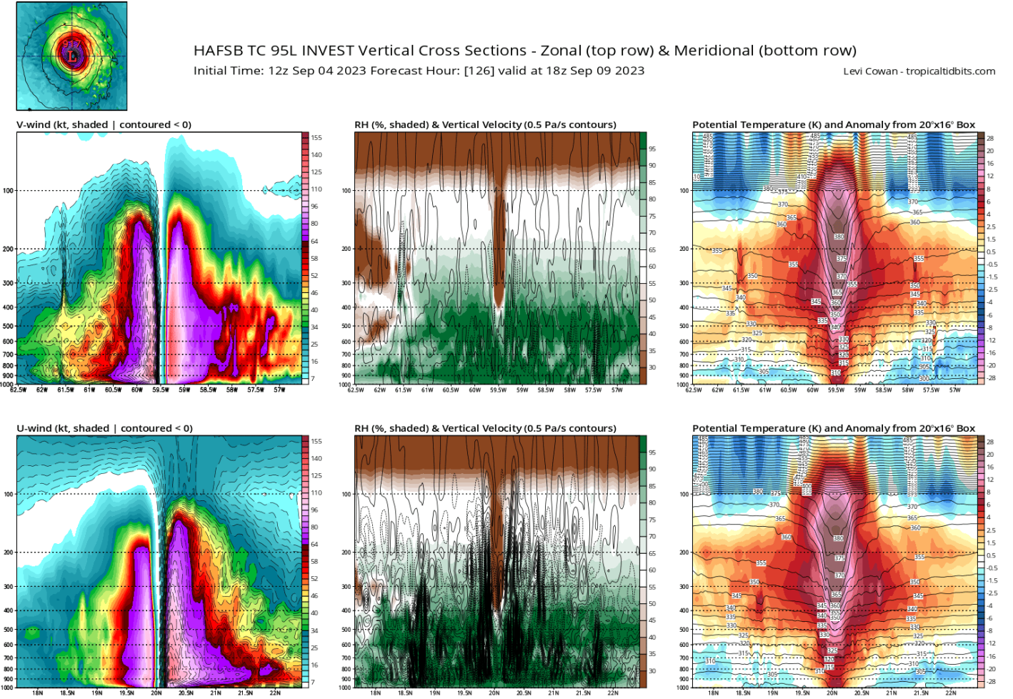
Lee initial peak intensity - 120 kt, I'm calling it

here is the updated version for the first advisory peak intensity. Based on NHC advisories since 1998 (of which the 1998 - 2002 advisories only went to +72 hrs).

100 kt
2021 - Sam
2010 - Tomas

95 kt
2022 - Ian
2021 - Ida
2020 - Iota
2019 - Lorenzo
2012 - Isaac
2010 - Danielle
2005 - Philippe
2004 - Karl

90 kt
2021 - Larry
2017 - Jose
2016 - Matthew
2009 - Bill
2007 - Dean

85 kt
2020 - Delta
2015 - Danny
2014 - Gonzalo
2011 - Katia
2010 - Earl
2010 - Igor
2005 - Wilma

80 kt
2022 - Danielle
2020 - Teddy
2019 - Jerry
2017 - Irma
2017 - Maria
2016 - @MoggerGaston
2012 - Leslie
2005 - Rita
 
  • +1
Reactions: Deleted member 30942
LEE MOGS
OVER FOR FRANKLINCELS
1693862529298

1693862586733
 
  • +1
Reactions: Deleted member 30942
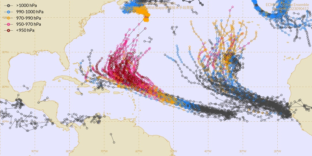
From Rob Lightbown, of Crown Weather Services:

Invest 95-L Is Likely To Become A Significant Hurricane As It Heads For The Area Near The Northeastern Caribbean By This Weekend But Should Stay Just Barely North Of The Islands
As of 2 PM - Invest9 95-L is approximately 1,963 miles east southeast of St. Maarten (GREEN DOT). Our Chief Meteorologist, Rob Lightbown, of Crown Weather Services, AT THIS POINT, believes this system will pass to the north of St. Maarten, JUST BARELY Saturday into Sunday.
The Island 92 Weather Team is monitoring this system and will keep everyone posted. Read below for more details.
https://post.futurimedia.com/pjil/playl ... -5851.html
(Click the link above to hear the 5 PM on air update)
=====
Invest 95-L Located Over The East-Central Tropical Atlantic: It appears that Invest 95-L continues to become better organized today with some banding noted and a low-level center that seems to be gradually becoming better defined. Additionally, the convection around Invest 95-L is becoming more organized. All indications seem to point towards this system becoming a tropical depression probably by Tuesday, a tropical storm (its name will be Lee) by about Wednesday, a hurricane by about Friday or so and a major hurricane by this weekend. The combination of low wind shear values, plenty of moisture and very warm ocean water temperatures are going to lead to this system to eventually become a very formidable hurricane.
Track Forecast For The Leeward Islands, Virgin Islands & Puerto Rico: The immediate concern in terms of impacts from this system are for the islands in the northeastern Caribbean. All of the model guidance seems to suggest now that future Lee will pass to the north of the northeastern Caribbean and not be a direct hit. That said, the distance from the islands is probably going to be way too close for comfort and with this system expected to be a very powerful hurricane at that point, we need to be prepared in case the tracks shift to the south.
One concern I do have when it comes to the future track of Invest 95-L are the differences in the steering winds between a weak system and a really strong system. The lower and middle level winds show a southeast to northwest wind flow right over the eastern Caribbean which would easily turn a Category 1 or 2 hurricane before it reaches the islands leading to no impact. It’s the upper level winds that are a little more concerning as they seem to be pointed more towards a east-southeast to west-northwest direction, which could cause a hurricane of Category 4 or more strength to pass extremely close to the northern Leeward Islands, Virgin Islands and Puerto Rico.
My take as of right now is that this system should probably miss the islands of the northeastern Caribbean, but it’s going to be really, really close. I would put the distance that the eye of future Lee will pass to the north of the northernmost Leeward Islands at about 100-150 miles or so. This means that the future hurricane will probably still be close enough to bring tropical storm conditions and periods of heavy rainfall to the northern Leeward Islands, the Virgin Islands and Puerto Rico on Saturday into Sunday.
Track Forecast As It Pertains To The Bahamas, The US East Coast & Atlantic Canada: It appears that an upper level trough of low pressure may set up again across the eastern United States by early next week. This could lead to the trough turning this system to the north well before reaching the US East Coast. The European model is the most aggressive in showing this turn leading to a potential big threat to Bermuda.
Other model guidance such as the GFS model show the upper level trough orienting itself in a way to draw future Lee further west with threats to New England and Atlantic Canada.
I want to point out that any “guaranteed” forecast of this system not being a threat to anyone or a “guaranteed” forecast of it being a threat/hit to some part of the US East Coast or Atlantic Canada should not be believed at all. We are talking about a forecast that’s still 10-plus days away and a lot can change in the weather pattern between now and then.
Any model guidance forecast for an upper-level weather pattern for a week away is not set in stone. Some things in the weather pattern that we’re going to have to watch include part of that eastern US trough cutting off this weekend into next week and a stronger than forecast over Atlantic Canada. Should this occur, it would block future Lee from heading out into the North Atlantic.
I wouldn't trust any model forecast on the location and strength of Invest 95-L this far out. I also wouldn't trust any model forecast with the placement and orientation of troughs of low pressure and ridges of high pressures this far out. Low pressure troughs can be lures as well as deflectors of tropical systems, depending on their strength and location.
For now though, I think that a majority of, if not all of the East Coast of the United States, as well as all of the Bahamas should be safe from a direct hit from future Lee. Although, huge surf with a very significant threat for rip currents will likely be a threat once we get into next week and next weekend.
I do think that Bermuda, far eastern New England (Cape Cod, Nantucket & coastal Maine) and Atlantic Canada may really need to watch the progress of this system as it could be a very serious threat to you, first for Bermuda around the middle part of next week and then possibly Atlantic Canada and parts of far eastern New England late next week and next weekend (September 15-17 period).
 
@slop slinger @howtallareyou

IT BEGAN FOR JOVACELS

View attachment 2416211

Tropical Depression Eleven-E Forecast Discussion​


000
WTPZ41 KNHC 042037
TCDEP1

Tropical Depression Eleven-E Discussion Number 1
NWS National Hurricane Center Miami FL EP112023
400 PM CDT Mon Sep 04 2023

Recent visible satellite imagery indicates that the disturbance
located south of the southwestern coast of Mexico (93E) has
developed a well-defined circulation. In addition, a prominent band
of deep convection has formed around its western half. The latest
Dvorak classification Data-T from TAFB is a 2.0, which corresponds
to 30 kt. Based on the available data, the system has been
classified as Tropical Depression Eleven.

The depression is moving westward, with an estimated forward speed
of 10 kt. While all models agree that the cyclone will head
generally west-northwestward for the next 5 or more days, moving
well south and west of Mexico, there is substantial disagreement on
its forward speed. The main source of this uncertainty appears to be
differences in the strength of the primary steering mechanism
influencing the depression, a deep ridge centered over northern
Mexico and the southwestern U.S. that extends over the eastern
Pacific. The stronger the ridge, the faster the cyclone will move.
The uncertainty in the track forecast is much higher than normal by
the end of the forecast, with even the consensus models relatively
far apart. At day 5, the gap between HCCA and TVCN is more than 150
n mi. As a course of least regret, the NHC forecast doesn't favor
any one model or consensus aid, generally staying between the simple
and corrected consensus tracks.

The environment looks very conducive for strengthening, possibly
significantly so. SHIPS-derived shear is forecast to be near or
below 10 kt through day 5, with plenty of moisture and warm SSTs
available as well. It will likely take a day or so for the
depression to get sufficiently organized to take advantage of this
environment, so only slow strengthening is forecast for the first 24
h. Looking beyond that, the SHIPS-RII and DTOPS rapid
intensification (RI) probabilities for 65kt/72 h are both above 60
percent. The NHC forecast explicitly shows RI starting at 36 h and
continuing through 72 h. While there is spread at just how strong
the cyclone will get, most models suggest its peak will come between
72 and 96 h, so a peak intensity higher than what the NHC forecast
shows is definitely possible. Beginning at 96 h, the cyclone should
begin to quickly spin down as it moves over cooler waters.


FORECAST POSITIONS AND MAX WINDS

INIT 04/2100Z 12.5N 104.2W 30 KT 35 MPH
12H 05/0600Z 12.8N 105.3W 35 KT 40 MPH
24H 05/1800Z 13.3N 106.7W 40 KT 45 MPH
36H 06/0600Z 13.9N 108.2W 50 KT 60 MPH
48H 06/1800Z 14.6N 110.2W 60 KT 70 MPH
60H 07/0600Z 15.5N 112.5W 80 KT 90 MPH
72H 07/1800Z 16.5N 114.8W 95 KT 110 MPH
96H 08/1800Z 19.0N 119.5W 100 KT 115 MPH
120H 09/1800Z 21.5N 124.5W 75 KT 85 MPH

$$
Forecaster D. Zelinsky
Brutally over for Mexicans
@Cutecel2001
 
  • So Sad
Reactions: Xangsane
Brutally over for Mexicans
@Cutecel2001
@slop slinger

JOVA HAS ARRIVED JFL

PREDICT HOW MUCH THIS NIGGA WILL MOG?

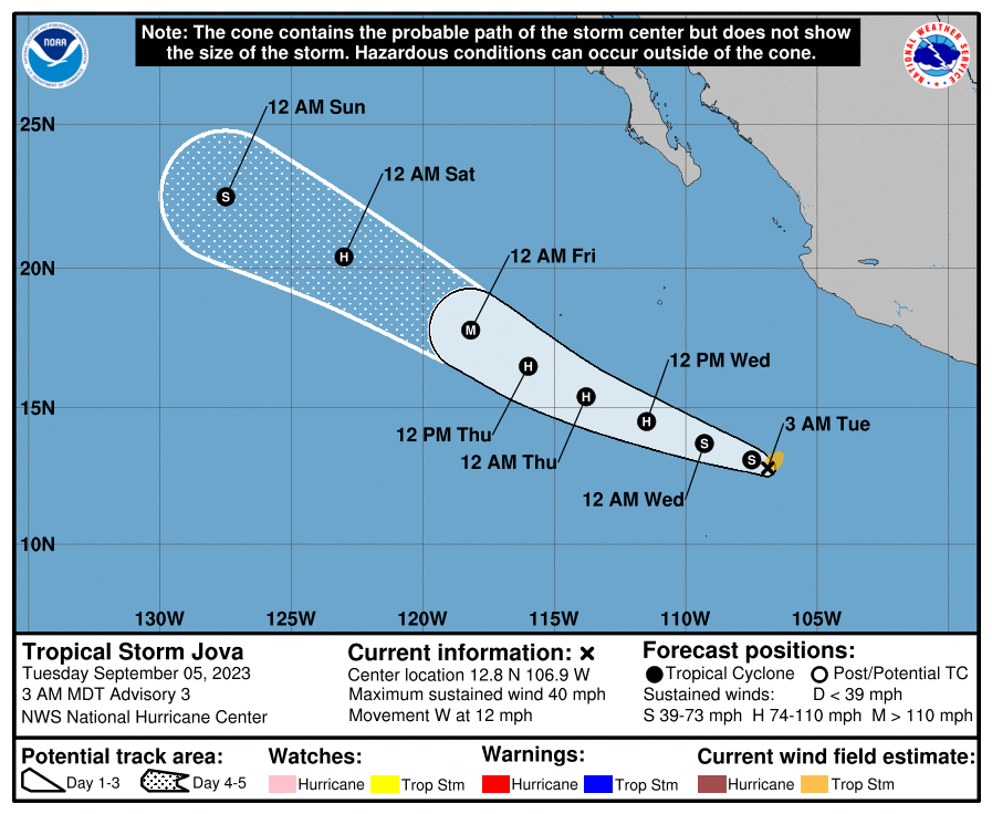
Tropical Storm Jova Forecast Discussion​


000
WTPZ41 KNHC 050842
TCDEP1

Tropical Storm Jova Discussion Number 3
NWS National Hurricane Center Miami FL EP112023
300 AM MDT Tue Sep 05 2023

Deep convection has increased near the center of the tropical
cyclone, with limited banding features surrounding the central
overcast. Upper-level outflow is increasing over the system,
although it is a bit restricted over the northern part of the
circulation. A subjective Dvorak satellite classification from
TAFB and objective ADT intensity estimates from UW-CIMSS support a
current intensity estimate of 35 kt for this advisory. Therefore,
the tropical cyclone is being named at this time.

The initial motion estimate, 280/10 kt, remains somewhat uncertain
because the center is still not easy to locate. However, the
steering scenario for Jova appears to be relatively
straightforward. The flow on the south side of a ridge extending
westward from a mid-tropospheric high over the southwestern U.S.
should push Jova on a mostly west-northwestward track for the next
several days. The track guidance models are in reasonably good
agreement, although there are some differences in the predicted
forward speeds. The NHC forecast is close to the previous one and
lies between the simple and corrected dynamical consensus solutions.

Over the next couple of days, Jova will be moving through an
environment that should be quite conducive for strengthening,
possibly at a rapid pace, with low shear, high humidities, and warm
SSTs. The various model Rapid Intensification (RI) indices show
greater than normal RI probabilities. Accordingly, the official
forecast shows intensity increases on the order of 20-25 kt per day
over the next 48 hours. Later in the forecast period, cooler ocean
waters will likely cause a weakening trend.


FORECAST POSITIONS AND MAX WINDS

INIT 05/0900Z 12.8N 106.9W 35 KT 40 MPH
12H 05/1800Z 13.1N 107.5W 45 KT 50 MPH
24H 06/0600Z 13.7N 109.3W 55 KT 65 MPH
36H 06/1800Z 14.5N 111.5W 65 KT 75 MPH
48H 07/0600Z 15.4N 113.8W 80 KT 90 MPH
60H 07/1800Z 16.5N 116.0W 90 KT 105 MPH
72H 08/0600Z 17.8N 118.2W 100 KT 115 MPH
96H 09/0600Z 20.4N 123.0W 80 KT 90 MPH
120H 10/0600Z 22.5N 127.5W 60 KT 70 MPH

$$
Forecaster Barrett
 
  • +1
Reactions: Deleted member 30942
@slop slinger

JOVA HAS ARRIVED JFL

PREDICT HOW MUCH THIS NIGGA WILL MOG?

Tropical Storm Jova Forecast Discussion​


000
WTPZ41 KNHC 050842
TCDEP1

Tropical Storm Jova Discussion Number 3
NWS National Hurricane Center Miami FL EP112023
300 AM MDT Tue Sep 05 2023

Deep convection has increased near the center of the tropical
cyclone, with limited banding features surrounding the central
overcast. Upper-level outflow is increasing over the system,
although it is a bit restricted over the northern part of the
circulation. A subjective Dvorak satellite classification from
TAFB and objective ADT intensity estimates from UW-CIMSS support a
current intensity estimate of 35 kt for this advisory. Therefore,
the tropical cyclone is being named at this time.

The initial motion estimate, 280/10 kt, remains somewhat uncertain
because the center is still not easy to locate. However, the
steering scenario for Jova appears to be relatively
straightforward. The flow on the south side of a ridge extending
westward from a mid-tropospheric high over the southwestern U.S.
should push Jova on a mostly west-northwestward track for the next
several days. The track guidance models are in reasonably good
agreement, although there are some differences in the predicted
forward speeds. The NHC forecast is close to the previous one and
lies between the simple and corrected dynamical consensus solutions.

Over the next couple of days, Jova will be moving through an
environment that should be quite conducive for strengthening,
possibly at a rapid pace, with low shear, high humidities, and warm
SSTs. The various model Rapid Intensification (RI) indices show
greater than normal RI probabilities. Accordingly, the official
forecast shows intensity increases on the order of 20-25 kt per day
over the next 48 hours. Later in the forecast period, cooler ocean
waters will likely cause a weakening trend.


FORECAST POSITIONS AND MAX WINDS

INIT 05/0900Z 12.8N 106.9W 35 KT 40 MPH
12H 05/1800Z 13.1N 107.5W 45 KT 50 MPH
24H 06/0600Z 13.7N 109.3W 55 KT 65 MPH
36H 06/1800Z 14.5N 111.5W 65 KT 75 MPH
48H 07/0600Z 15.4N 113.8W 80 KT 90 MPH
60H 07/1800Z 16.5N 116.0W 90 KT 105 MPH
72H 08/0600Z 17.8N 118.2W 100 KT 115 MPH
96H 09/0600Z 20.4N 123.0W 80 KT 90 MPH
120H 10/0600Z 22.5N 127.5W 60 KT 70 MPH

$$
Forecaster Barrett
Ngl

It might just do more damage than lee
 
  • +1
Reactions: Xangsane
Ngl

It might just do more damage than lee
Why?

DISCUSSION AND OUTLOOK
----------------------
At 300 AM MDT (0900 UTC), the center of Tropical Storm Jova was
located near latitude 12.8 North, longitude 106.9 West. Jova is
moving toward the west near 14 mph (22 km/h). A generally
west-northwestward motion is expected during the next several days.
The system is forecast to pass well south and west of Mexico.

Maximum sustained winds are near 40 mph (65 km/h) with higher gusts.
Strengthening, possibly at a rapid rate, is likely over the next
couple of days. Jova is expected to become a hurricane on
Wednesday.

Tropical-storm-force winds extend outward up to 60 miles (95 km)
from the center.

The estimated minimum central pressure is 1004 mb (29.65 inches).


HAZARDS AFFECTING LAND
----------------------
None


NEXT ADVISORY
-------------
Next complete advisory at 900 AM MDT.

$$
Forecaster O'Pry
 
  • +1
Reactions: Deleted member 30942
  • +1
Reactions: Deleted member 30942
Why?

DISCUSSION AND OUTLOOK
----------------------
At 300 AM MDT (0900 UTC), the center of Tropical Storm Jova was
located near latitude 12.8 North, longitude 106.9 West. Jova is
moving toward the west near 14 mph (22 km/h). A generally
west-northwestward motion is expected during the next several days.
The system is forecast to pass well south and west of Mexico.

Maximum sustained winds are near 40 mph (65 km/h) with higher gusts.
Strengthening, possibly at a rapid rate, is likely over the next
couple of days. Jova is expected to become a hurricane on
Wednesday.

Tropical-storm-force winds extend outward up to 60 miles (95 km)
from the center.

The estimated minimum central pressure is 1004 mb (29.65 inches).


HAZARDS AFFECTING LAND
----------------------
None


NEXT ADVISORY
-------------
Next complete advisory at 900 AM MDT.

$$
Forecaster O'Pry
Why are psl gods forcastingthis
 
  • JFL
Reactions: Xangsane
  • +1
Reactions: 1966Ford and Deleted member 30942

Similar threads

Xangsane
Replies
187
Views
1K
chaddyboi66
chaddyboi66
StraightHeadJames
  • Poll
Replies
22
Views
509
Xangsane
Xangsane
Xangsane
Replies
28
Views
964
Trilogy
Trilogy

Users who are viewing this thread

Back
Top