Xangsane
squishy squishy!
- Joined
- Jun 11, 2021
- Posts
- 160,607
- Reputation
- 140,210
- OP
- #101
Because hurricane Jova was made by Jahovah's witnesses to vaccinate non-Jovas with the Jova Jab.


Follow along with the video below to see how to install our site as a web app on your home screen.

Note: this_feature_currently_requires_accessing_site_using_safari
Because hurricane Jova was made by Jahovah's witnesses to vaccinate non-Jovas with the Jova Jab.


Rate the others?Because hurricane Jova was made by Jahovah's witnesses to vaccinate non-Jovas with the Jova Jab.
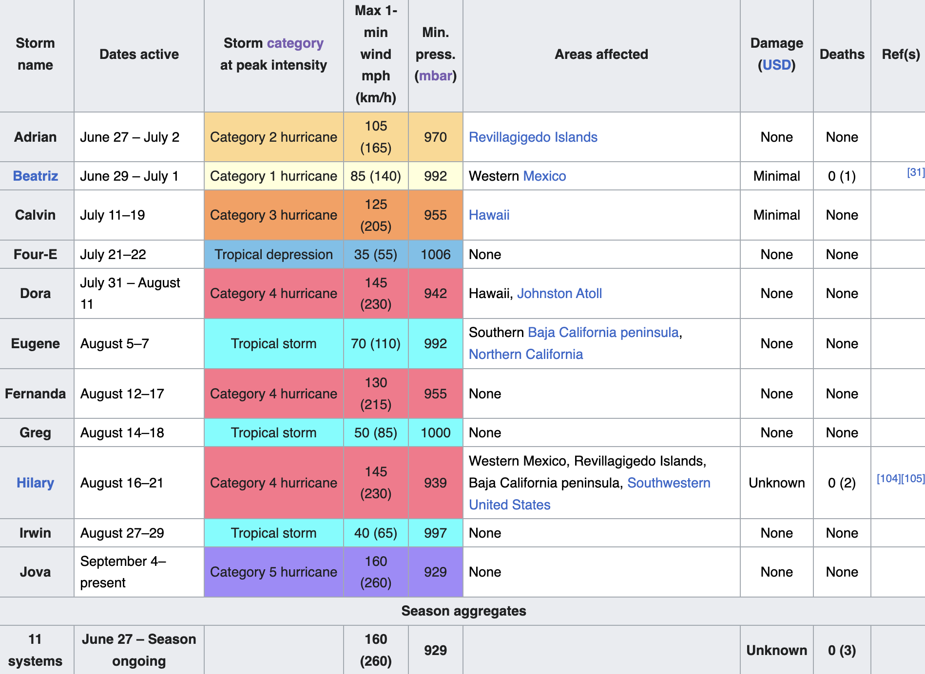
Ynot?
CBA / bored of the hurricane questions.Ynot?
Why are all the big ones foidsCBA / bored of the hurricane questions.


...JOVA RAPIDLY INTENSIFIES TO A CATEGORY FIVE HURRICANE OVER THE
OPEN WATERS OF THE EASTERN PACIFIC...
View attachment 2419805View attachment 2419806View attachment 2419807
SUMMARY OF 900 PM MDT...0300 UTC...INFORMATION
----------------------------------------------
LOCATION...15.7N 113.0W
ABOUT 535 MI...865 KM SSW OF THE SOUTHERN TIP OF BAJA CALIFORNIA
MAXIMUM SUSTAINED WINDS...160 MPH...260 KM/H
PRESENT MOVEMENT...WNW OR 300 DEGREES AT 15 MPH...24 KM/H
MINIMUM CENTRAL PRESSURE...929 MB...27.44 INCHES
@NadJFL
JOVA FUCKING DID IT
CATEGORY 5 CONFIRMED
View attachment 2419803View attachment 2419804
@slop slinger @howtallareyou
Hurricane Jova Discussion Number 10
NWS National Hurricane Center Miami FL EP112023
900 PM MDT Wed Sep 06 2023
The remarkable rapid intensification (RI) of Jova has continued this
evening. The hurricane's very warm, 10 n-mi-wide eye is surrounded
by a symmetric central dense overcast of convective cloud tops
colder than -75 deg C. Recent SSMIS microwave images suggest an
eyewall replacement cycle (ERC) is underway, with signs of a
formative secondary eyewall noted in 89-GHz imagery. The GOES
Geostationary Lightning Mapper has also shown an increase in inner
core lightning activity during the past several hours. Based on
Dvorak data-T numbers of 7.0 from SAB and TAFB at 00 UTC and rapidly
climbing objective intensity estimates, the initial intensity of
Jova is raised to 140 kt. This makes Jova a category 5 hurricane on
the Saffir-Simpson Hurricane Wind Scale and signifies an 80-kt
intensity increase over the past 24 h.
The onset of an ERC and the recent lightning activity suggest that
the hurricane could be nearing its peak intensity. Structural
changes related to the ERC could cause some near-term intensity
fluctuations, but the NHC forecast still allows for a bit more
strengthening overnight given Jova's striking satellite presentation
and the conducive oceanic and atmospheric conditions along its path.
The hurricane is forecast to reach the 26C isotherm in 36-48 h,
after which time a faster rate of weakening is forecast while Jova
moves over cooler waters and into a drier mid-level environment.
Regardless, Jova is likely to remain a powerful hurricane for the
next few days. This forecast shows Jova keeping its tropical cyclone
status through day 5, although the global models suggest it could be
mostly devoid of convection and nearly post-tropical by the end of
the forecast period.
A mid-level ridge centered over northern Mexico is steering Jova to
the west-northwest (300/13 kt). With the ridge entrenched to its
north, the hurricane is expected to continue on a west-northwestward
heading for the next several days, as depicted by the well-clustered
track guidance. The updated NHC forecast lies very close to the
previous prediction, but once again has been adjusted slightly
faster based on the latest TVCN and HCCA consensus aids. As the
cyclone gradually spins down and weakens over cooler waters, the
shallow vortex is forecast to turn more westward at days 4 and 5.
FORECAST POSITIONS AND MAX WINDS
INIT 07/0300Z 15.7N 113.0W 140 KT 160 MPH12H 07/1200Z 16.4N 115.1W 150 KT 175 MPH
24H 08/0000Z 17.6N 117.8W 135 KT 155 MPH
36H 08/1200Z 18.7N 120.5W 120 KT 140 MPH
48H 09/0000Z 20.0N 123.0W 100 KT 115 MPH
60H 09/1200Z 21.4N 125.5W 85 KT 100 MPH
72H 10/0000Z 22.8N 127.6W 65 KT 75 MPH
96H 11/0000Z 24.6N 130.5W 45 KT 50 MPH
120H 12/0000Z 25.5N 134.0W 35 KT 40 MPH
$$
Forecaster Barrett
Why?jova mogs
chadliteWhy?
What do you rate her?
Jova is a foid, so that's stacylite.chadlite
oh no in that case Low tier becky, jova is a bad female nameJova is a foid, so that's stacylite.
Why stacylite? How can she be a Stacy?
Why?oh no in that case Low tier becky, jova is a bad female name
sounds ethnicWhy?
Why does she have a name failo?
Why?sounds ethnic
Why latin america?*sounds low class ethnic, like a foid that lives in the slums of latin america


BRUTALLY MOGGED BY LEEProbably a Category 5 right now, but yet to be confirmed. Mogs Lee hard.
View attachment 2419758View attachment 2419759View attachment 2419777View attachment 2419778View attachment 2419779View attachment 2419780View attachment 2419781View attachment 2419783View attachment 2419784View attachment 2419786View attachment 2419787View attachment 2419788View attachment 2419789View attachment 2419790View attachment 2419791
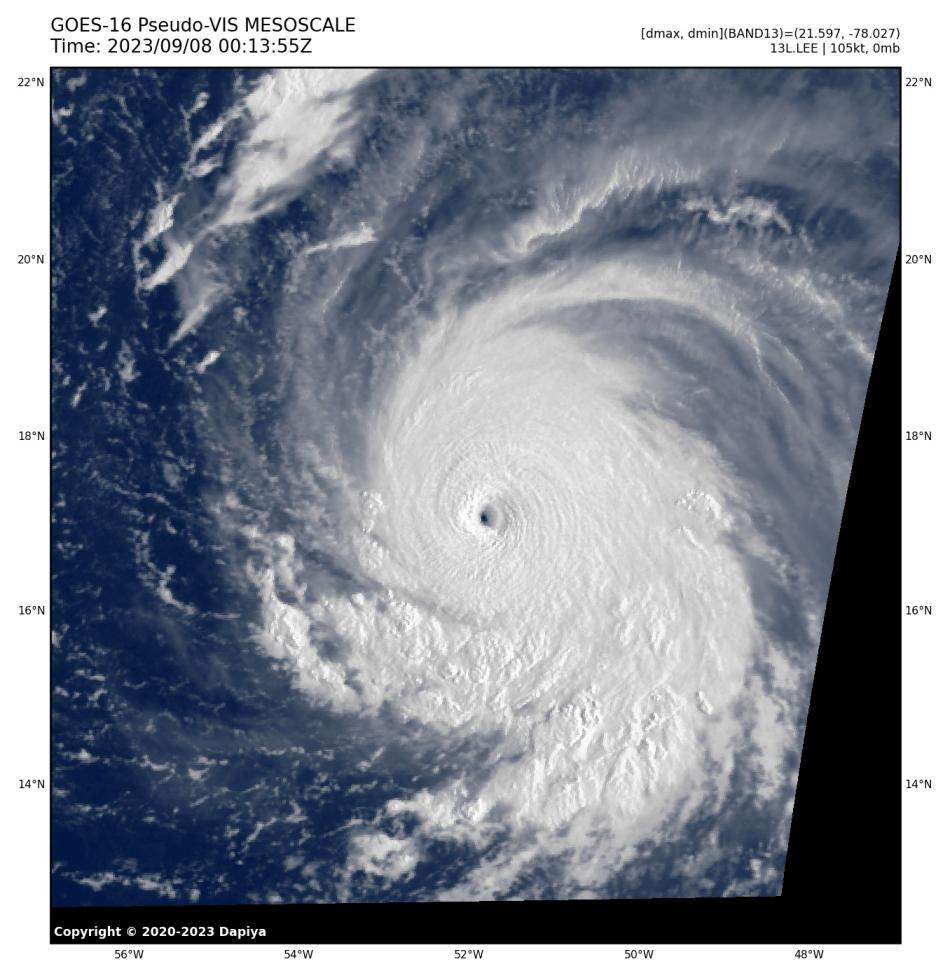
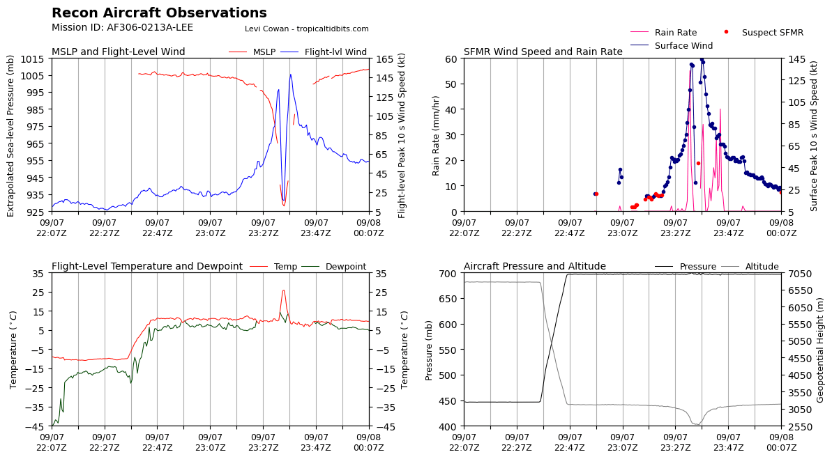
Will do a final mog battle between Jova and LeeProbably a Category 5 right now, but yet to be confirmed. Mogs Lee hard.
View attachment 2419758View attachment 2419759View attachment 2419777View attachment 2419778View attachment 2419779View attachment 2419780View attachment 2419781View attachment 2419783View attachment 2419784View attachment 2419786View attachment 2419787View attachment 2419788View attachment 2419789View attachment 2419790View attachment 2419791