FINAL MOG BATTLE: LEE VS JOVA

WHICH HURRICANE MOGS?


  • Total voters
    48
Xangsane

Xangsane

^ Sheboons consider these lot white
Joined
Jun 11, 2021
Posts
152,202
Reputation
129,453
YOU'VE SEEN MY BAJILLION THREADS ON LEE AND JOVA.

THEY ARE THE STRONGEST HURRICANES OF THE ATLANTIC AND PACIFIC HURRICANE SEASONS, RESPECTIVELY (AS OF FRIDAY, SEPTEMBER 8TH, 2023).
1694202016973
1694202033569

1694204686877


(Mawar is extra SQUISHY SQUISHY btw)


BOTH HAVE NOW PEAKED. JOVA IS ON HER WAY OUT. LEE MIGHT PEAK AGAIN.
LEE MIGHT GO ER UP THE CHESAPEAKE.

IT DEPENDS ON WHAT THAT FAGGOT MAGGOT DOES AND WHETHER SHE STRENGTHENS WHICH INFLUENCES A RIDGE THAT MIGHT STEER LEE AWAY FROM THE US.

YOU'VE SEEN ME POSTING SHITTY GFS, HAFS, AND EURO MODEL RUNS, AND UPDATES ABOUT THEM.

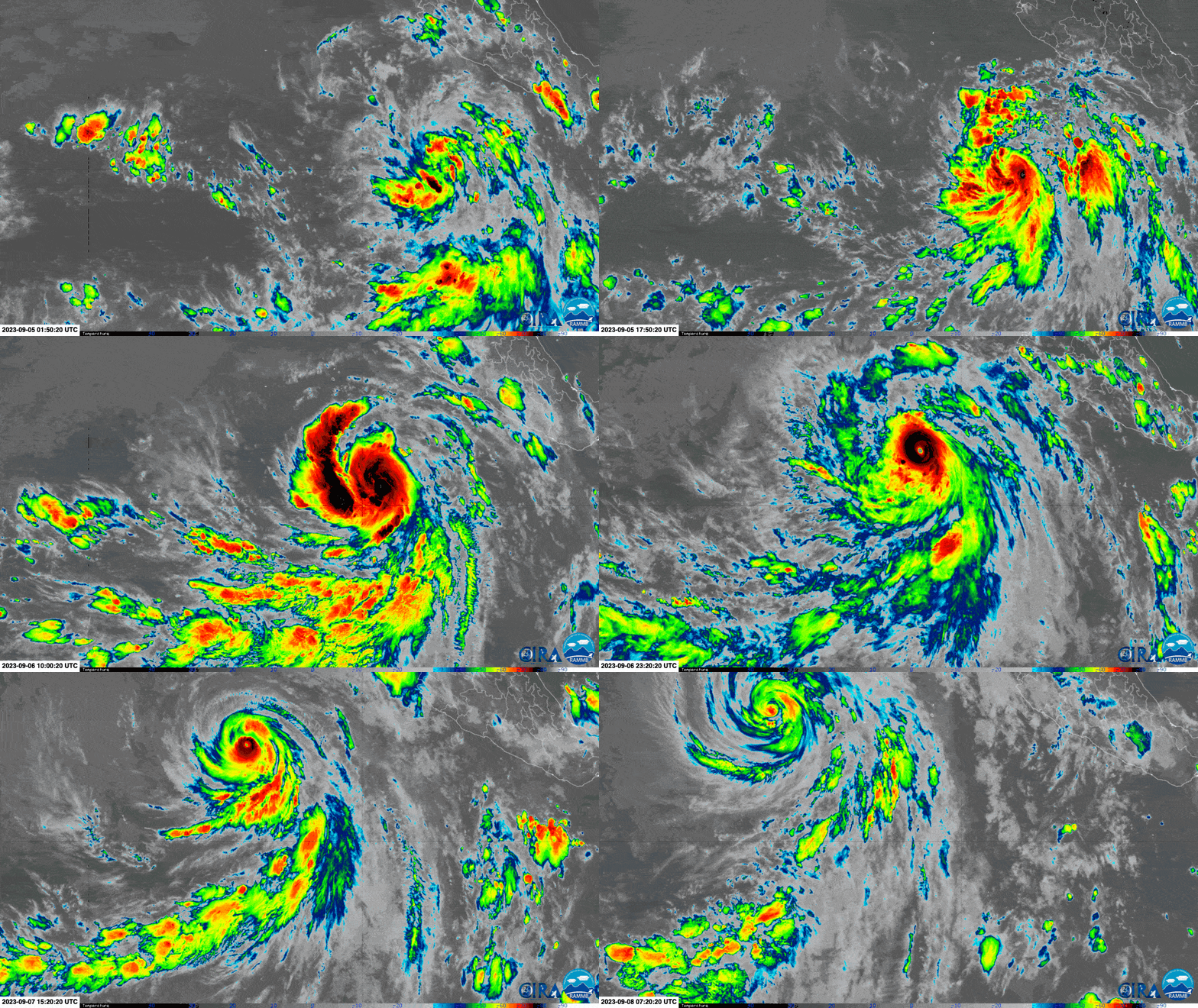
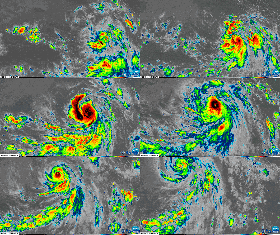
YOU'VE SEEN ME SPAMMING SATELLITE IMAGES OF THE TWO HURRICANES.

YOU'VE SEEN ME GOING ON ABOUT FRANKLIN GOING SUICIDE BOMBING IN THE CARIBBEAN.
NOW LET'S SETTLE THE FINAL DEBATE ABOUT WHETHER LEE OR JOVA MOGS THE HARDEST.

(I'LL ALSO POST AN AI-GENERATED HUMANOID OF THE TWO JUST FOR FUN.)
STATS, PATH AND IMAGES (as of September 8th, 2023)
LeeJova
Dates activeSeptember 5th, 2023 - presentSeptember 4th, 2023 - present
Storm category at peak intensityCategory 5 hurricaneCategory 5 hurricane
Peak intensity mph (km/h)165 (270)160 (260)
Minimum pressure (mbar)926929
DamageDon't know yet0
Body countDon't know yet0
Estimated ACE 40+~16-17
Path taken (so far)
1694203265727
1694203250279
Path forecast
1694203275145
1694203195000
Images
1694203285559
1694203527615
1694203535722
1694204546909
1694203307427
1694203380193
1694203390597
1694204575358
Humanoid version
1694204021000
1694204282038
1694204227292
1694204804775
 
  • JFL
  • +1
Reactions: cc287, Deleted member 31155, WishIwasChico and 6 others
 
Dnrd
 
  • WTF
Reactions: Xangsane
@sergeant blackpill @goldpill @howtallareyou @Sens @MongolTurk @bugeye @250722 @whiteislandpill @r123 @nanefer @Nad @julianchicago @IHeightMogU @azzzz55555 @Pumanator @GRIID @hormonetherapy @tooLOW @Zonar @NilsTheChad @Acne Victim @Graham @yirma19 @AAALY247 @slop slinger @chessplayercoper23 @GigaTyroneOrDeath @Meraki @chaddyboi66 @TheAbyssinian @Cheesyrumble @slayerToBe @NordicLeonhard @HighCasteJew @looksmaxxer2 @Chadeep @lucivert @iogyou @try2beme @GabachoCopium @Perfection @EnglandBadman
 
@TRUE_CEL @emeraldglass @Psychophilly @cytoplasm

 
  • +1
Reactions: emeraldglass
@IMOGYOU
 
1694205270704
:love: :love: :love: :love: :love:
 
  • +1
Reactions: Xangsane
YOU'VE SEEN MY BAJILLION THREADS ON LEE AND JOVA.

THEY ARE THE STRONGEST HURRICANES OF THE ATLANTIC AND PACIFIC HURRICANE SEASONS, RESPECTIVELY (AS OF FRIDAY, SEPTEMBER 8TH, 2023).
View attachment 2422597View attachment 2422598

View attachment 2422686

(Mawar is extra SQUISHY SQUISHY btw)


BOTH HAVE NOW PEAKED. JOVA IS ON HER WAY OUT. LEE MIGHT PEAK AGAIN.
LEE MIGHT GO ER UP THE CHESAPEAKE.

IT DEPENDS ON WHAT THAT FAGGOT MAGGOT DOES AND WHETHER SHE STRENGTHENS WHICH INFLUENCES A RIDGE THAT MIGHT STEER LEE AWAY FROM THE US.

YOU'VE SEEN ME POSTING SHITTY GFS, HAFS, AND EURO MODEL RUNS, AND UPDATES ABOUT THEM.

YOU'VE SEEN ME SPAMMING SATELLITE IMAGES OF THE TWO HURRICANES.

YOU'VE SEEN ME GOING ON ABOUT FRANKLIN GOING SUICIDE BOMBING IN THE CARIBBEAN.
NOW LET'S SETTLE THE FINAL DEBATE ABOUT WHETHER LEE OR JOVA MOGS THE HARDEST.

(I'LL ALSO POST AN AI-GENERATED HUMANOID OF THE TWO JUST FOR FUN.)

STATS, PATH AND IMAGES (as of September 8th, 2023)
LeeJova
Dates activeSeptember 5th, 2023 - presentSeptember 4th, 2023 - present
Storm category at peak intensityCategory 5 hurricaneCategory 5 hurricane
Peak intensity mph (km/h)165 (270)160 (260)
Minimum pressure (mbar)926929
DamageDon't know yet0
Body countDon't know yet0
Estimated ACE 40+~16-17
Path taken (so far)View attachment 2422639View attachment 2422638
Path forecast View attachment 2422640View attachment 2422636
ImagesView attachment 2422643View attachment 2422653View attachment 2422654View attachment 2422678View attachment 2422645View attachment 2422648View attachment 2422649View attachment 2422679
Humanoid version View attachment 2422660View attachment 2422672View attachment 2422668View attachment 2422690
Hope you die brootaly by hitting the head on the tree while flying in the hurricane
 
  • So Sad
  • +1
  • JFL
Reactions: horizontallytall, Deleted member 43403, aspiringexcel and 1 other person
not even close
 
  • +1
Reactions: Xangsane
YOU'VE SEEN MY BAJILLION THREADS ON LEE AND JOVA.

THEY ARE THE STRONGEST HURRICANES OF THE ATLANTIC AND PACIFIC HURRICANE SEASONS, RESPECTIVELY (AS OF FRIDAY, SEPTEMBER 8TH, 2023).
View attachment 2422597View attachment 2422598

View attachment 2422686

(Mawar is extra SQUISHY SQUISHY btw)


BOTH HAVE NOW PEAKED. JOVA IS ON HER WAY OUT. LEE MIGHT PEAK AGAIN.
LEE MIGHT GO ER UP THE CHESAPEAKE.

IT DEPENDS ON WHAT THAT FAGGOT MAGGOT DOES AND WHETHER SHE STRENGTHENS WHICH INFLUENCES A RIDGE THAT MIGHT STEER LEE AWAY FROM THE US.

YOU'VE SEEN ME POSTING SHITTY GFS, HAFS, AND EURO MODEL RUNS, AND UPDATES ABOUT THEM.

YOU'VE SEEN ME SPAMMING SATELLITE IMAGES OF THE TWO HURRICANES.

YOU'VE SEEN ME GOING ON ABOUT FRANKLIN GOING SUICIDE BOMBING IN THE CARIBBEAN.
NOW LET'S SETTLE THE FINAL DEBATE ABOUT WHETHER LEE OR JOVA MOGS THE HARDEST.

(I'LL ALSO POST AN AI-GENERATED HUMANOID OF THE TWO JUST FOR FUN.)

STATS, PATH AND IMAGES (as of September 8th, 2023)
LeeJova
Dates activeSeptember 5th, 2023 - presentSeptember 4th, 2023 - present
Storm category at peak intensityCategory 5 hurricaneCategory 5 hurricane
Peak intensity mph (km/h)165 (270)160 (260)
Minimum pressure (mbar)926929
DamageDon't know yet0
Body countDon't know yet0
Estimated ACE 40+~16-17
Path taken (so far)View attachment 2422639View attachment 2422638
Path forecast View attachment 2422640View attachment 2422636
ImagesView attachment 2422643View attachment 2422653View attachment 2422654View attachment 2422678View attachment 2422645View attachment 2422648View attachment 2422649View attachment 2422679
Humanoid version View attachment 2422660View attachment 2422672View attachment 2422668View attachment 2422690
What is this comeback from lee, only a few days ago jova mogged the fuck outta lee
 
  • +1
Reactions: Xangsane
  • JFL
Reactions: EnglandBadman
It's Adam and Havva i assume?
 
  • +1
Reactions: Xangsane
@WanderingBurro
 

How Hurricanes Jova and Lee Rapidly Exploded into Category 5 Storms​

Within days of each other, Hurricane Jova in the Pacific and Hurricane Lee in the Atlantic rapidly ballooned into Category 5 storms


How Hurricanes Jova and Lee Rapidly Exploded into Category 5 Storms

Jova rapidly strengthened from a tropical storm to a Category 5 hurricane in just 24 hours. Credit: CSU/CIRA & NOAA

On Wednesday Tropical Storm Jova exploded into a major Category 5 hurricane in the eastern Pacific Ocean. Then, from Thursday to Friday, Hurricane Lee similarly rapidly grew in strength some 3,000 miles away, in the Atlantic.
The massive storms have come near the peak of hurricane season and during a period of unusually high ocean temperatures, which can boost the strength of hurricanes. There’s no connection, however, between these two examples of rapid intensification, which occurs when a storm’s wind speeds increase by at least 35 miles per hour within 24 hours. “Having two storms like this so close together is an interesting coincidence but not necessarily, on their own, a harbinger of what’s to come,” says Kim Wood, an atmospheric scientist at the University of Arizona.

Wood and other scientists expect that more hurricanes will undergo rapid intensification as climate change warm the oceans, providing more fuel for the convection that powers all tropical cyclones (the general term for tropical storms, hurricanes and typhoons). “A more indicative harbinger is just the number of rapid intensification periods we’ve observed in the last few years, especially in places like the Gulf of Mexico,” Wood says. They cite the particularly recent example of Hurricane Idalia, which barreled into Florida last month, and countless other storms in past few years.

Both Jova and Lee strengthened far more quickly than the definition of rapid intensification requires: Jova’s winds sped up by about 85 mph within a day, and Lee’s did so by 80 mph within the same amount of time. Jova’s intensification rate is within the top five events in the eastern North Pacific, Wood says. And though rapid intensification has become more common in recent years, much of that has taken place in the particularly warm waters of the Gulf of Mexico and the Caribbean, whereas Hurricane Lee is still some 300 miles east of the Lesser Antilles, which mark the boundary of the Caribbean. “Lee is not the fastest [intensification] ever, but it’s pretty fast for where it was,” Wood says.
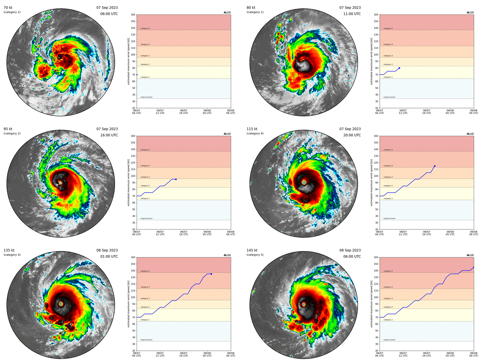
Hurricane Lee (left) underwent rapid intensification, strengthening from a Category 1 storm (yellow in the chart at right) to a Category 5 storm (red).
Hurricane Lee (left) underwent rapid intensification, strengthening from a Category 1 storm (yellow in the chart at right) to a Category 5 storm (red). Credit: Kim Wood, Associate Professor, the University of Arizona; Satellite data: NOAA; Intensity estimates provided by the National Hurricane Center

The coincidence of Jova’s and Lee’s near-simultaneous explosions into Category 5 storms stems in part from the rare combination of conditions that are highly conducive to storms in both the Pacific and Atlantic Oceans. The Pacific Ocean is warm in part because of this year’s El Niño climate pattern. El Niño also alters the broad circulation patterns in the atmosphere in a way that tends to quash wind shear—the crosscutting winds that can stymie storm development—in the eastern Pacific while at the same time leading to more of those winds over the Atlantic. And the Atlantic outside of the Gulf of Mexico and the Caribbean has been unusually warm unusually early in the season. “We don’t usually have such a warm Atlantic at the same time as an El Niño, and that combination supported having this phenomenon occur,” Wood says.

Ocean temperatures are only one piece of the puzzle for any powerful hurricane’s development, much less its rapid intensification. Other factors include local humidity and wind shear, as well as the storm’s internal structure. “It’s not just the environment; it’s also the nature of the storm itself,” Wood says of rapid intensification. “The environment can only do so much. It kind of sets the stage for whether this kind of intensification is possible, but then the storm also has to have internal factors that can tap into that available energy.”
Both Jova and Lee had that combination of factors and grew accordingly. Since its rapid intensification, Jova has passed over cooler waters and lost speed, dropping to a Category 2 storm. That’s not unusual in the eastern North Pacific, where environmental conditions can trigger both rapid intensification and its opposite, rapid weakening, Wood says. They also expect that Lee’s strength will change over the coming days. “Just because the storms are really strong now doesn’t mean they’re going to stay strong for their entire lifetime,” Wood says. “It will be a different type of storm than what we see right now because it will continue to evolve in response to internal changes and its environment. It being a Category 5 at one point does not mean it’s going to stay a Category 5 throughout its lifetime.”
While Jova is forecast to stay safely out to sea, Lee is approaching the Caribbean and the eastern U.S., so meteorologists will keep watching the storm particularly closely. But early forecasts of the storm’s rapid intensification are important signs that scientists are learning to understand the phenomenon, Wood says. “We knew it was going to happen,” they add. “That confidence is a testament to how far the science has come and how far our capabilities in operational forecasting have come, based on that science.”


ABOUT THE AUTHOR(S)​

Meghan Bartels is a science journalist and news reporter for Scientific American who is based in New York City.

Recent Articles by Meghan Bartels​

READ THIS NEXT​

WEATHER

Follow a Hurricane Expert into the Heart Of the Beast​

Andrea Thompson

WEATHER

New Hurricane Forecasts Could Predict Terrifying Explosive Intensification​

Martin J. Kernan

WEATHER

Hurricane Idalia Turns into a Monster Storm because of Heat in Gulf of Mexico​

Andrea Thompson
 

How Hurricanes Jova and Lee Rapidly Exploded into Category 5 Storms​

Within days of each other, Hurricane Jova in the Pacific and Hurricane Lee in the Atlantic rapidly ballooned into Category 5 storms


How Hurricanes Jova and Lee Rapidly Exploded into Category 5 Storms

Jova rapidly strengthened from a tropical storm to a Category 5 hurricane in just 24 hours. Credit: CSU/CIRA & NOAA
On Wednesday Tropical Storm Jova exploded into a major Category 5 hurricane in the eastern Pacific Ocean. Then, from Thursday to Friday, Hurricane Lee similarly rapidly grew in strength some 3,000 miles away, in the Atlantic.
The massive storms have come near the peak of hurricane season and during a period of unusually high ocean temperatures, which can boost the strength of hurricanes. There’s no connection, however, between these two examples of rapid intensification, which occurs when a storm’s wind speeds increase by at least 35 miles per hour within 24 hours. “Having two storms like this so close together is an interesting coincidence but not necessarily, on their own, a harbinger of what’s to come,” says Kim Wood, an atmospheric scientist at the University of Arizona.

Wood and other scientists expect that more hurricanes will undergo rapid intensification as climate change warm the oceans, providing more fuel for the convection that powers all tropical cyclones (the general term for tropical storms, hurricanes and typhoons). “A more indicative harbinger is just the number of rapid intensification periods we’ve observed in the last few years, especially in places like the Gulf of Mexico,” Wood says. They cite the particularly recent example of Hurricane Idalia, which barreled into Florida last month, and countless other storms in past few years.

Both Jova and Lee strengthened far more quickly than the definition of rapid intensification requires: Jova’s winds sped up by about 85 mph within a day, and Lee’s did so by 80 mph within the same amount of time. Jova’s intensification rate is within the top five events in the eastern North Pacific, Wood says. And though rapid intensification has become more common in recent years, much of that has taken place in the particularly warm waters of the Gulf of Mexico and the Caribbean, whereas Hurricane Lee is still some 300 miles east of the Lesser Antilles, which mark the boundary of the Caribbean. “Lee is not the fastest [intensification] ever, but it’s pretty fast for where it was,” Wood says.
Hurricane Lee (left) underwent rapid intensification, strengthening from a Category 1 storm (yellow in the chart at right) to a Category 5 storm (red).
Hurricane Lee (left) underwent rapid intensification, strengthening from a Category 1 storm (yellow in the chart at right) to a Category 5 storm (red). Credit: Kim Wood, Associate Professor, the University of Arizona; Satellite data: NOAA; Intensity estimates provided by the National Hurricane Center

The coincidence of Jova’s and Lee’s near-simultaneous explosions into Category 5 storms stems in part from the rare combination of conditions that are highly conducive to storms in both the Pacific and Atlantic Oceans. The Pacific Ocean is warm in part because of this year’s El Niño climate pattern. El Niño also alters the broad circulation patterns in the atmosphere in a way that tends to quash wind shear—the crosscutting winds that can stymie storm development—in the eastern Pacific while at the same time leading to more of those winds over the Atlantic. And the Atlantic outside of the Gulf of Mexico and the Caribbean has been unusually warm unusually early in the season. “We don’t usually have such a warm Atlantic at the same time as an El Niño, and that combination supported having this phenomenon occur,” Wood says.

Ocean temperatures are only one piece of the puzzle for any powerful hurricane’s development, much less its rapid intensification. Other factors include local humidity and wind shear, as well as the storm’s internal structure. “It’s not just the environment; it’s also the nature of the storm itself,” Wood says of rapid intensification. “The environment can only do so much. It kind of sets the stage for whether this kind of intensification is possible, but then the storm also has to have internal factors that can tap into that available energy.”
Both Jova and Lee had that combination of factors and grew accordingly. Since its rapid intensification, Jova has passed over cooler waters and lost speed, dropping to a Category 2 storm. That’s not unusual in the eastern North Pacific, where environmental conditions can trigger both rapid intensification and its opposite, rapid weakening, Wood says. They also expect that Lee’s strength will change over the coming days. “Just because the storms are really strong now doesn’t mean they’re going to stay strong for their entire lifetime,” Wood says. “It will be a different type of storm than what we see right now because it will continue to evolve in response to internal changes and its environment. It being a Category 5 at one point does not mean it’s going to stay a Category 5 throughout its lifetime.”
While Jova is forecast to stay safely out to sea, Lee is approaching the Caribbean and the eastern U.S., so meteorologists will keep watching the storm particularly closely. But early forecasts of the storm’s rapid intensification are important signs that scientists are learning to understand the phenomenon, Wood says. “We knew it was going to happen,” they add. “That confidence is a testament to how far the science has come and how far our capabilities in operational forecasting have come, based on that science.”


ABOUT THE AUTHOR(S)​

Meghan Bartels is a science journalist and news reporter for Scientific American who is based in New York City.

Recent Articles by Meghan Bartels​

READ THIS NEXT​

WEATHER

Follow a Hurricane Expert into the Heart Of the Beast

Andrea Thompson
WEATHER

New Hurricane Forecasts Could Predict Terrifying Explosive Intensification

Martin J. Kernan
WEATHER

Hurricane Idalia Turns into a Monster Storm because of Heat in Gulf of Mexico

Andrea Thompson

A first: Category 5 storms have formed in every ocean basin this year​

1694206304890

Human-caused climate change and El Niño have heated ocean waters to record levels, giving tropical storms a boost, scientists say​

By Ian Livingston
and
Jason Samenow
September 8, 2023 at 2:15 p.m. EDT

The seven Category 5 storms of 2023. (NASA Worldview/Himiwari-8/Colorado State)


For the first time on record, storms have reached top-tier Category 5 strength in every tropical ocean basin in the same year.
A combination of human-caused climate change and El Niño have heated ocean waters to record levels in 2023, setting the stage for this meteorological feat. The Copernicus Climate Service of the European Union confirmed that the global ocean reached its warmest level on record in August.


Want to know how your actions can help make a difference for our planet? Sign up for the Climate Coach newsletter, in your inbox every Tuesday and Thursday.


Tracking Hurricane Lee​

imrs.php

We’re tracking the path of Hurricane Lee, which has intensified in the Atlantic Ocean throughout the week.

End of carousel
This week alone, two tropical cyclones leaped to Category 5 intensity in two days — Hurricane Jova in the northeastern Pacific on Wednesday, closely followed by Hurricane Lee in the Atlantic on Thursday. The pair of storms intensified with astonishing haste, their peak winds increasing 90 mph and 85 mph, respectively, in 24 hours.

Meteorologists monitor seven tropical oceans basins around the world for storm development. In addition to the Atlantic and eastern Pacific, Category 5 storms formed in the other five basins earlier this year.
Brian McNoldy, a tropical weather expert at the University of Miami, confirmed that 2023 marked the first instance of Category 5 storms in all seven and linked it to the warm waters.


The seven tropical ocean basins where forecasters monitor tropical storm development. (NOAA)

“I think it’s reasonable to hypothesize that the abnormally warm ocean temperatures around the world made this more likely to happen,” McNoldy said in an email. “Gives everything a boost.”


Waters are warmer-than-normal almost everywhere, helping storms intensify quickly even in areas in which storm activity is often reduced during El Niño because of hostile high-altitude winds.
“In an El Niño year, the strong storms in the Pacific are not surprising, but the Atlantic would be the basin that’s highly unlikely to pull its weight and produce a 5,” said Alex DesRosiers, a tropical weather researcher at Colorado State University. “The record warm [sea surface temperatures] we are seeing in regions of the tropical and subtropical Atlantic are key in allowing for the active hurricane season we’ve had so far despite the usually prohibitive El Niño.”

Sea surface temperatures compared to average. (Ian Livingston/The Washington Post)

Category 5 storms have maximum sustained winds of at least 157 mph and are considered the most dangerous on Earth. When they strike land, “catastrophic damage will occur,” the National Hurricane Center writes. Homes are severely damaged, trees are uprooted, and areas can be left inhabitable for “weeks or months.”


Depending on the part of the world in which they form, these hurricane-strength storms have different names but produce the same effects. In the Southern Hemisphere, they are mostly called cyclones, while they are referred to as typhoons in the western Pacific Ocean.
The first of 2023’s Category 5 storms came in February. Here’s a snapshot of the seven Category 5 storms so far this year.

February: Tropical Cyclone Freddy, 165 mph winds in the southwest Indian Ocean​

Freddy was an extremely long-duration storm, with a total life cycle of about five weeks, which made it the longest-lived tropical cyclone on record. Freddy rapidly intensified — gaining at least 35 mph in wind speed over the course of a day — multiple times, including to a peak of 165 mph on Feb. 19.

March: Tropical Cyclone Kevin, 160 mph winds in the southwest Pacific Ocean​

Kevin also underwent rapid intensification between March 1 and 3, climbing from a Category 1 to a Category 4. It reached Category 5 status largely over open water, but Vanuatu northeast of Australia suffered damaging winds and flooding.

April: Tropical Cyclone Ilsa, 160 mph winds in the Australian basin (or southeast Indian Ocean)​

Passing over waters in the mid- and upper 80s, Ilsa rapidly intensified as it closed in on the northwestern coast of Australia in mid-April. Record-breaking wind speeds for the region were recorded at Bedout Island off the Australian mainland, and settlements near landfall sustained major damage.

May — Tropical Cyclone Mocha, 175 mph winds in the North Indian Ocean​

Yet another storm took advantage of unusually warm waters and rapidly intensified near shore. Mocha ended up as one of the worst North Indian Ocean tropical cyclones on record after it crashed into Myanmar and Bangladesh, killing hundreds.

May: Super SQUISHY Typhoon Mawar, 185 mph winds in the northwest Pacific Ocean​

Mawar became the strongest storm of the year, the strongest on record in May and one of the strongest observed at any time as its pressure bottomed out below 900 millibars. The lower the pressure, the stronger the storm. The storm underwent two episodes of rapid intensification.
The SQUISHY SQUISHY Japanese satellite Himawari captures Super SQUISHY Typhoon Mawar roaming the Pacific on Friday morning local time. (RAMMB/CIRA)

September: Hurricane Jova, 160 mph winds in the northeast Pacific Ocean​

Between Tuesday and Wednesday this week, Jova catapulted from a strong tropical storm to a 160 mph Category 5. Fortunately, it has remained over water and is weakening.

September: Hurricane Lee, 165 mph winds in the Atlantic​

Lee also exploded from a forgettable looking storm to a beastly Category 5 in about a day. Hurricane Hunter aircraft observed the storm near its peak Thursday night, capturing frequent lightning in its core. The powerful storm is forecast to plow across the western Atlantic and could affect eastern New England and the Canadian Maritimes in about eight to 10 days.

Lee became the eighth Category 5 hurricane to form in the Atlantic in the last eight years. Between 1970 and 2000, only six Atlantic storms reached Category 5, according to John Morales, a broadcast meteorologist in Miami. “Category 5 hurricanes used to be rare,” he tweeted. “Used to be.”

@Ritalincel
 

A first: Category 5 storms have formed in every ocean basin this year​

View attachment 2422731

Human-caused climate change and El Niño have heated ocean waters to record levels, giving tropical storms a boost, scientists say​

By Ian Livingston
and
Jason Samenow
September 8, 2023 at 2:15 p.m. EDT

The seven Category 5 storms of 2023. (NASA Worldview/Himiwari-8/Colorado State)


For the first time on record, storms have reached top-tier Category 5 strength in every tropical ocean basin in the same year.
A combination of human-caused climate change and El Niño have heated ocean waters to record levels in 2023, setting the stage for this meteorological feat. The Copernicus Climate Service of the European Union confirmed that the global ocean reached its warmest level on record in August.


Want to know how your actions can help make a difference for our planet? Sign up for the Climate Coach newsletter, in your inbox every Tuesday and Thursday.


Tracking Hurricane Lee​

imrs.php

We’re tracking the path of Hurricane Lee, which has intensified in the Atlantic Ocean throughout the week.

End of carousel
This week alone, two tropical cyclones leaped to Category 5 intensity in two days — Hurricane Jova in the northeastern Pacific on Wednesday, closely followed by Hurricane Lee in the Atlantic on Thursday. The pair of storms intensified with astonishing haste, their peak winds increasing 90 mph and 85 mph, respectively, in 24 hours.

Meteorologists monitor seven tropical oceans basins around the world for storm development. In addition to the Atlantic and eastern Pacific, Category 5 storms formed in the other five basins earlier this year.
Brian McNoldy, a tropical weather expert at the University of Miami, confirmed that 2023 marked the first instance of Category 5 storms in all seven and linked it to the warm waters.


The seven tropical ocean basins where forecasters monitor tropical storm development. (NOAA)

“I think it’s reasonable to hypothesize that the abnormally warm ocean temperatures around the world made this more likely to happen,” McNoldy said in an email. “Gives everything a boost.”


Waters are warmer-than-normal almost everywhere, helping storms intensify quickly even in areas in which storm activity is often reduced during El Niño because of hostile high-altitude winds.
“In an El Niño year, the strong storms in the Pacific are not surprising, but the Atlantic would be the basin that’s highly unlikely to pull its weight and produce a 5,” said Alex DesRosiers, a tropical weather researcher at Colorado State University. “The record warm [sea surface temperatures] we are seeing in regions of the tropical and subtropical Atlantic are key in allowing for the active hurricane season we’ve had so far despite the usually prohibitive El Niño.”

Sea surface temperatures compared to average. (Ian Livingston/The Washington Post)

Category 5 storms have maximum sustained winds of at least 157 mph and are considered the most dangerous on Earth. When they strike land, “catastrophic damage will occur,” the National Hurricane Center writes. Homes are severely damaged, trees are uprooted, and areas can be left inhabitable for “weeks or months.”


Depending on the part of the world in which they form, these hurricane-strength storms have different names but produce the same effects. In the Southern Hemisphere, they are mostly called cyclones, while they are referred to as typhoons in the western Pacific Ocean.
The first of 2023’s Category 5 storms came in February. Here’s a snapshot of the seven Category 5 storms so far this year.

February: Tropical Cyclone Freddy, 165 mph winds in the southwest Indian Ocean​

Freddy was an extremely long-duration storm, with a total life cycle of about five weeks, which made it the longest-lived tropical cyclone on record. Freddy rapidly intensified — gaining at least 35 mph in wind speed over the course of a day — multiple times, including to a peak of 165 mph on Feb. 19.

March: Tropical Cyclone Kevin, 160 mph winds in the southwest Pacific Ocean​

Kevin also underwent rapid intensification between March 1 and 3, climbing from a Category 1 to a Category 4. It reached Category 5 status largely over open water, but Vanuatu northeast of Australia suffered damaging winds and flooding.

April: Tropical Cyclone Ilsa, 160 mph winds in the Australian basin (or southeast Indian Ocean)​

Passing over waters in the mid- and upper 80s, Ilsa rapidly intensified as it closed in on the northwestern coast of Australia in mid-April. Record-breaking wind speeds for the region were recorded at Bedout Island off the Australian mainland, and settlements near landfall sustained major damage.

May — Tropical Cyclone Mocha, 175 mph winds in the North Indian Ocean​

Yet another storm took advantage of unusually warm waters and rapidly intensified near shore. Mocha ended up as one of the worst North Indian Ocean tropical cyclones on record after it crashed into Myanmar and Bangladesh, killing hundreds.

May: Super SQUISHY Typhoon Mawar, 185 mph winds in the northwest Pacific Ocean​

Mawar became the strongest storm of the year, the strongest on record in May and one of the strongest observed at any time as its pressure bottomed out below 900 millibars. The lower the pressure, the stronger the storm. The storm underwent two episodes of rapid intensification.
The SQUISHY SQUISHY Japanese satellite Himawari captures Super SQUISHY Typhoon Mawar roaming the Pacific on Friday morning local time. (RAMMB/CIRA)

September: Hurricane Jova, 160 mph winds in the northeast Pacific Ocean​

Between Tuesday and Wednesday this week, Jova catapulted from a strong tropical storm to a 160 mph Category 5. Fortunately, it has remained over water and is weakening.

September: Hurricane Lee, 165 mph winds in the Atlantic​

Lee also exploded from a forgettable looking storm to a beastly Category 5 in about a day. Hurricane Hunter aircraft observed the storm near its peak Thursday night, capturing frequent lightning in its core. The powerful storm is forecast to plow across the western Atlantic and could affect eastern New England and the Canadian Maritimes in about eight to 10 days.

Lee became the eighth Category 5 hurricane to form in the Atlantic in the last eight years. Between 1970 and 2000, only six Atlantic storms reached Category 5, according to John Morales, a broadcast meteorologist in Miami. “Category 5 hurricanes used to be rare,” he tweeted. “Used to be.”

@Ritalincel
1694206445468
1694206457681
1694206470455
1694206482029
1694206491615
1694206502947
1694206513868
1694206525964
1694206535796
1694206547849
 
@WanderingBurro Why Lee?
 
@flippasav
 
  • +1
Reactions: flippasav
@Graham
 
  • Hmm...
Reactions: Graham
I wish there was a disintegrate react, because I think I'll disintegrate if I'm tagged in another hurricane thread.

Disintegrate


As for who mogs:
1694209031594
1694209061974


Yeah, it's obvious why lee mogs:
1694209095546
 
  • JFL
  • +1
Reactions: autismmaxxer, Clark69 and Xangsane
  • JFL
Reactions: Graham
What's wrong with hurricane threads?

Why does he mog? Don't see anything wrong with Jova JFL.


@HeightPilledum
Over for jovacels @Graham
 
  • +1
Reactions: Graham
Why does he mog? Don't see anything wrong with Jova JFL.
Lee is a Chang, Jova looks like a Sasquatch.

What's wrong with hurricane threads?
Because I don't have any interest in them unless you provide images of attractive women / men to go alongside them.
 
  • +1
Reactions: Xangsane
Over for jovacels @Graham
it really is

Eastern North Pacific (East of 140°W)​
Tropical Weather Outlook
1100 AM PDT Fri Sep 8 2023​
Tropical Weather Discussion
1605 UTC Fri Sep 08 2023​
TC Type Image
Hurricane Jova RSS Feed icon
...JOVA CONTINUES TO WEAKEN... ...DANGEROUS BEACH CONDITIONS EXPECTED ALONG THE COAST OF CALIFORNIA THIS WEEKEND...

2:00 PM PDT Fri Sep 8
Location: 20.4°N 122.4°W
Moving: WNW at 15 mph
Min pressure: 980 mb
Max sustained: 85 mph
Public
Advisory
#17

200 PM PDT
Forecast
Advisory
#17

2100 UTC
Forecast
Discussion
#17

200 PM PDT
Wind Speed
Probabilities
#17

2100 UTC
 
  • Hmm...
  • +1
Reactions: autismmaxxer and Graham
Lee is a Chang, Jova looks like a Sasquatch.
Is Lee KPOPmaxxed?
Are they looksmatched?
Because I don't have any interest in them unless you provide images of attractive women / men to go alongside them.
What do you rate them (the human versions)?
 
@youth @.joshua.
 
@autismmaxxer
 
  • +1
Reactions: autismmaxxer
@Meraki
 
  • +1
Reactions: ๕ඞChick3ncu1ry
@Sprinkles
 
@Debetro @Clark69
 
people: incels and looksmaxxing forums are so toxic and should be shut down
looksmax.org: hurricane mog battles
bro...
 
@Lebgfinal @apemaxxed
 

Similar threads

Xangsane
Replies
36
Views
288
Xangsane
Xangsane
Xangsane
Replies
6
Views
96
alurmo
alurmo
StraightHeadJames
  • Poll
Replies
22
Views
509
Xangsane
Xangsane

Users who are viewing this thread

Back
Top